


Despite a stated goal of encouraging other modes, the city's streets still overwhelmingly prioritize cars.
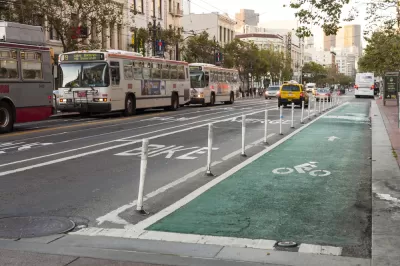
Almost a half century after San Francisco first passed its "Transit-First" policy, writes Dan Federman, "less than 5 percent of [the city's] limited road space actually prioritizes transit."
To assess the way San Francisco uses its street space, Federman calculates the lane miles on San Francisco's streets, roughly 5,593.6 lane miles. "In 2019, SFMTA published a blog post saying that the city had painted 43 miles of transit-only lanes. Then in 2021 SFMTA announced that it was attempting to make 20 miles of recently created temporary transit-only lanes permanent," for a total of 63 permanent transit-only lanes. SFMTA has also "declared a goal of creating 45 lane-miles of protected bike lanes by 2021. Let’s give SFMTA the benefit of the doubt and assume that the city achieved its goal."
Federman concludes that "[i]n total, only 210.8 lane-miles prioritize alternatives to travel by private automobile in San Francisco. The remaining 5,382.8 lane-miles of road prioritize cars. In other words, more than 95 percent of our roads prioritizes cars," belying the city's stated goal to "encourage the use of public rights of way by pedestrians, bicyclists, and public transit."
FULL STORY: What Happened to “Transit First?”


Opinion: San Francisco Needs a Well-Funded Transit System
Muni ridership is above pre-pandemic levels on some lines. Why is the agency still considering service cuts?
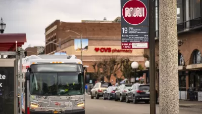
San Francisco Muni Sees Highest Ridership Since Start of Pandemic
The SFMTA is improving service at off-peak hours and on weekends to accommodate new travel patterns that rely less on weekday commuters. Ridership has increased accordingly.

San Francisco Seeks Public Input on Post-Pandemic Muni Service
The SFMTA is considering a "high-access network" that would let people reach more destinations and increase frequency on some Muni lines.

Planetizen Federal Action Tracker
A weekly monitor of how Trump’s orders and actions are impacting planners and planning in America.

Map: Where Senate Republicans Want to Sell Your Public Lands
For public land advocates, the Senate Republicans’ proposal to sell millions of acres of public land in the West is “the biggest fight of their careers.”

Restaurant Patios Were a Pandemic Win — Why Were They so Hard to Keep?
Social distancing requirements and changes in travel patterns prompted cities to pilot new uses for street and sidewalk space. Then it got complicated.

Albuquerque Route 66 Motels Become Affordable Housing
A $4 million city fund is incentivizing developers to breathe new life into derelict midcentury motels.

DC Area County Eliminates Bus Fares
Montgomery County joins a growing trend of making transit free.

Platform Pilsner: Vancouver Transit Agency Releases... a Beer?
TransLink will receive a portion of every sale of the four-pack.
Urban Design for Planners 1: Software Tools
This six-course series explores essential urban design concepts using open source software and equips planners with the tools they need to participate fully in the urban design process.
Planning for Universal Design
Learn the tools for implementing Universal Design in planning regulations.
Heyer Gruel & Associates PA
JM Goldson LLC
Custer County Colorado
City of Camden Redevelopment Agency
City of Astoria
Transportation Research & Education Center (TREC) at Portland State University
Camden Redevelopment Agency
City of Claremont
Municipality of Princeton (NJ)