


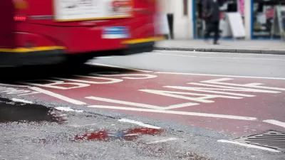
In an effort to improve on-time performance of Muni, San Francisco has begun painting transit-only lanes a shade of Golden Gate Bridge red.
Jessica Kwong reports on the city’s new look for transit-only lanes: a deep shade of red that will alert drivers to the proper use of the lanes.
The first red lanes actually appeared almost a year ago “as part of a pilot project on Church Street between 16th Street and Duboce Avenue to improve the movement of J-Church trains and 22-Fillmore buses.”
The city is currently painting on Third Street between Townsend and Jessie streets, with additional work scheduled for “on eastbound Market Street between Fifth and 12th streets, westbound Market Street between Eighth Street and Van Ness Avenue, and Geary and O'Farrell streets between Market and Gough streets, except for the segment between Powell Street and Grant Avenue.”
SFMTA Transportation Director Ed Reiskin is quoted in the story making a telling statement about how San Francisco prioritizes the use of its public right-of-ways: "As a transit-first city, we need to be smart about how we improve transit to make it an attractive, reliable choice for San Franciscans."
FULL STORY: SF coloring lanes red to indicate transit-only

San Francisco Transit-Only Lane Controversy Heating Up
Public opinion is split on the red transit-only lanes found around San Francisco. Next week, the public will get a chance to air their grievances, or defend their territory.
San Francisco's Red Transit-Only Lanes Improving Service
For years, San Francisco has set aside transit-only lanes. However, with a fresh coat of red paint, the city has seen significant service improvements.
San Francisco's Red Carpet Transit Lanes to Continue Through March Evaluation
San Francisco's red, transit-only lanes are a demonstration project. The lanes first appeared in 2013 and were supposed to last two years, with state and federal regulators to determine whether they would continue. The state evaluation began Dec. 6.

Planetizen Federal Action Tracker
A weekly monitor of how Trump’s orders and actions are impacting planners and planning in America.

Map: Where Senate Republicans Want to Sell Your Public Lands
For public land advocates, the Senate Republicans’ proposal to sell millions of acres of public land in the West is “the biggest fight of their careers.”

Restaurant Patios Were a Pandemic Win — Why Were They so Hard to Keep?
Social distancing requirements and changes in travel patterns prompted cities to pilot new uses for street and sidewalk space. Then it got complicated.

Platform Pilsner: Vancouver Transit Agency Releases... a Beer?
TransLink will receive a portion of every sale of the four-pack.

Toronto Weighs Cheaper Transit, Parking Hikes for Major Events
Special event rates would take effect during large festivals, sports games and concerts to ‘discourage driving, manage congestion and free up space for transit.”

Berlin to Consider Car-Free Zone Larger Than Manhattan
The area bound by the 22-mile Ringbahn would still allow 12 uses of a private automobile per year per person, and several other exemptions.
Urban Design for Planners 1: Software Tools
This six-course series explores essential urban design concepts using open source software and equips planners with the tools they need to participate fully in the urban design process.
Planning for Universal Design
Learn the tools for implementing Universal Design in planning regulations.
Heyer Gruel & Associates PA
JM Goldson LLC
Custer County Colorado
City of Camden Redevelopment Agency
City of Astoria
Transportation Research & Education Center (TREC) at Portland State University
Camden Redevelopment Agency
City of Claremont
Municipality of Princeton (NJ)