


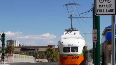
The historic streetcars will connect uptown and downtown amenities in a 4.8-mile loop.
The City of El Paso saw the return of its streetcar last weekend, reports Lisa Sanchez, "[e]xciting news for El Pasoans who have missed taking a ride down memory lane in our El Paso Streetcars."
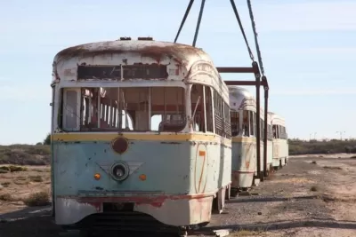
The historic trolleys date back to trolley carts first installed in 1902 to replace the city's mule car system, which then expanded into a full streetcar system that served El Pasoans during the 1950s through 1970s. According to Destination El Paso, "[t]he project began with the construction of 4.8 miles of track, 27 stops, a maintenance and storage facility and associated infrastructure, along with the remanufacture of streetcars that used to serve El Paso." Today, six streetcars are back in service.
"The Streetcar travels a 4.8-mile route in two loops through El Paso’s uptown and downtown areas. Both loops interconnect an international bridge, an array of businesses and restaurants, a baseball park, government buildings, historic neighborhoods, hospitals, and higher education institutions like the University of Texas at El Paso amongst many other prominent locations." Riders can also connect to other Sun Metro services. "The El Paso Streetcars will run Thursday, Friday, and Saturday from 4 p.m. to midnight. The streetcar will be free during these times and for the first weekend, streetcar passengers can park for free the weekend of July 29th - July 31st at the Glory Road Transfer Center at UTEP."
FULL STORY: The El Paso Streetcar Is Back and You Can Ride For Free

El Paso Streetcar Marries History, Mobility, and Economic Development
The city’s streetcar line, defunct since 1974, is moving thousands of riders through a newly revitalized downtown.
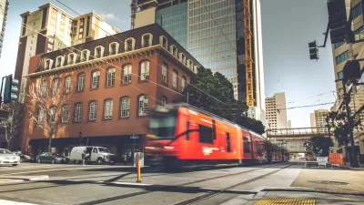
San Diego Trolley Extension Launch a 'Rousing Success'
San Diego's new trolley extension, which serves UC San Diego and communities near the U.S.-Mexico border, saw strong ridership numbers on its opening day.

Officials Kill St. Paul Streetcar, BRT Proposals
The proposed transit lines would have linked the St. Paul airport, downtown, and the Mall of America.

Planetizen Federal Action Tracker
A weekly monitor of how Trump’s orders and actions are impacting planners and planning in America.

Maui's Vacation Rental Debate Turns Ugly
Verbal attacks, misinformation campaigns and fistfights plague a high-stakes debate to convert thousands of vacation rentals into long-term housing.

Restaurant Patios Were a Pandemic Win — Why Were They so Hard to Keep?
Social distancing requirements and changes in travel patterns prompted cities to pilot new uses for street and sidewalk space. Then it got complicated.

In California Battle of Housing vs. Environment, Housing Just Won
A new state law significantly limits the power of CEQA, an environmental review law that served as a powerful tool for blocking new development.

Boulder Eliminates Parking Minimums Citywide
Officials estimate the cost of building a single underground parking space at up to $100,000.

Orange County, Florida Adopts Largest US “Sprawl Repair” Code
The ‘Orange Code’ seeks to rectify decades of sprawl-inducing, car-oriented development.
Urban Design for Planners 1: Software Tools
This six-course series explores essential urban design concepts using open source software and equips planners with the tools they need to participate fully in the urban design process.
Planning for Universal Design
Learn the tools for implementing Universal Design in planning regulations.
Heyer Gruel & Associates PA
JM Goldson LLC
Custer County Colorado
City of Camden Redevelopment Agency
City of Astoria
Transportation Research & Education Center (TREC) at Portland State University
Jefferson Parish Government
Camden Redevelopment Agency
City of Claremont