


The thirst for urban expansion and new highway capacity hit a roadblock on the fringe of the Dallas-Fort Worth metropolis.
A contentious battle over a planned expansion of Highway 380 in the Dallas-Fort Worth region is detailed in a recent article by Peter Simek.
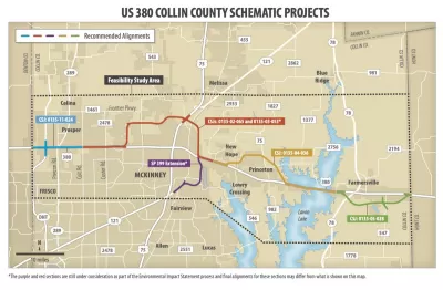
Highway 380 is "hardly more than a little two-lane road," according to Simek, connecting remote farming communities between Greenville and into New Mexico, passing through the city of McKinney, where Simek lays the scene.
"In 2016, residents living along Highway 380 received notices from the Texas Department of Transportation informing them that Highway 380 would soon be transformed into a major freeway—a limited-access traffic artery as wide as 10 lanes in parts."
TxDOT is proposing the expansion in response to previous growth that has expanded the footprint of Dallas-Fort Worth region to these former agricultural lands. And more growth is expected: "According to the Texas Demographic Center, Collin County’s population is expected to grow from fewer than 800,000 people in 2010 to more than 3.8 million by 2050," according to Simek.
Growth or not, residents of McKinney aren't happy about the TxDOT's plans for Highway 280.
But just as traffic engineers tend to see limited-access freeways as the best solution to the challenges of urban growth, people generally don’t want freeways running through their backyards. As TxDOT began rolling out a suite of options for the design and location of the new freeway, the Highway 380 planning process devolved into the most contentious community battle in Collin County history.
The TxDOT chose a preferred alternative, with an estimated cost of $2.5 billion, for the expansion in March 2019 and embarked on an environmental study of the project at the beginning of 2020. Simek's focus, however, is on the local opposition to the plan, and the coalition of local residents and organizations working to prevent the project, turning neighbor against neighbor, in some cases, along the way.
FULL STORY: Does McKinney Really Need a New Highway?


Planning for Congestion Relief
The third and final installment of Planetizen's examination of the role of the planning profession in both perpetuating and solving traffic congestion.

How Planning Fails to Solve Congestion
Solutions for congestion are never as simple and easy as armchair planners and engineers would like you to believe—especially those who suggest that congestion can be solved by forever building more roadway capacity.

Planning and the Complicated Causes and Effects of Congestion
What do planners know about congestion, and what can they do about it? Explanations and solutions are less obvious than they seem (part one of a three-part series).

Planetizen Federal Action Tracker
A weekly monitor of how Trump’s orders and actions are impacting planners and planning in America.

Map: Where Senate Republicans Want to Sell Your Public Lands
For public land advocates, the Senate Republicans’ proposal to sell millions of acres of public land in the West is “the biggest fight of their careers.”

Restaurant Patios Were a Pandemic Win — Why Were They so Hard to Keep?
Social distancing requirements and changes in travel patterns prompted cities to pilot new uses for street and sidewalk space. Then it got complicated.

Platform Pilsner: Vancouver Transit Agency Releases... a Beer?
TransLink will receive a portion of every sale of the four-pack.

Toronto Weighs Cheaper Transit, Parking Hikes for Major Events
Special event rates would take effect during large festivals, sports games and concerts to ‘discourage driving, manage congestion and free up space for transit.”

Berlin to Consider Car-Free Zone Larger Than Manhattan
The area bound by the 22-mile Ringbahn would still allow 12 uses of a private automobile per year per person, and several other exemptions.
Urban Design for Planners 1: Software Tools
This six-course series explores essential urban design concepts using open source software and equips planners with the tools they need to participate fully in the urban design process.
Planning for Universal Design
Learn the tools for implementing Universal Design in planning regulations.
Heyer Gruel & Associates PA
JM Goldson LLC
Custer County Colorado
City of Camden Redevelopment Agency
City of Astoria
Transportation Research & Education Center (TREC) at Portland State University
Camden Redevelopment Agency
City of Claremont
Municipality of Princeton (NJ)