


The New York Department of Transportation is changing the way it plans and manages open streets as political support for the concept wavers.
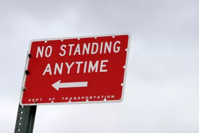
"The [New York City] Department of Transportation has abruptly scuttled the Upper West Side’s only north-south open street," according to an article by Streetsblog New York City. The story about the nine-block stretch of West End Avenue between 87th and 96th streets is indicative of the city's recent retreat from car-free ambitions that gained political will and public momentum in the city during the pandemic.
According to the article, Upper West Side residents and organizations are being told by the NYCDOT that community groups will be necessary to "manage" and "enforce" new open streets.
Here's how the article describes the open street back in its heyday:
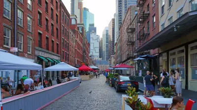
During the spring and early summer, when many Upper West Siders fleeing the city, the West End Avenue open street offered residents a quieter neighborhood, low traffic, a slower pace and, most important, a safe place to get outside at a proper distance. Some residents pulled out lawn chairs; others taught their kids to ride bikes. One doorman led the neighbors in nightly 7 p.m. “whoop” for essential workers.
That was before. In recent months, according to the article, the street started filling up with cars again—creating conflicts that have been materializing in New York City with greater frequency in recent weeks. The political power of car-centric use of public space has also been evident in the city's slow rollout of a bus priority program announced in June.
Based on the report, the decision to end the West End Avenue open street isn't the result of a push by the city to improve community buy-in, similar to steps taken to address equity in open streets planning during the pandemic in Oakland, California. In New York City, the political cause is traced to a specific "pro-parking, pro-driving agitator."
FULL STORY: ANATOMY OF A DEBACLE: DOT Eliminates Open Street on West End Avenue

Open Streets and Outdoor Dining Are Best for Business, Report Says
Most business owners believe that they'd be out of business without on-street parking near their front door. The experience of New York City during the pandemic proves otherwise.

The Tide Has Turned Against Open Streets
Once a promising development for advocates pushing for a less car-centric future in cities, the open streets movement has ceded significant ground to cars since the height of the pandemic.
Permanent Car-Free Streets in Manhattan's Meatpacking District
The local Business Improvement District has decided to permanently block cars from a large swath of Manhattan's Meatpacking District.

Maui's Vacation Rental Debate Turns Ugly
Verbal attacks, misinformation campaigns and fistfights plague a high-stakes debate to convert thousands of vacation rentals into long-term housing.

Planetizen Federal Action Tracker
A weekly monitor of how Trump’s orders and actions are impacting planners and planning in America.

In Urban Planning, AI Prompting Could be the New Design Thinking
Creativity has long been key to great urban design. What if we see AI as our new creative partner?

King County Supportive Housing Program Offers Hope for Unhoused Residents
The county is taking a ‘Housing First’ approach that prioritizes getting people into housing, then offering wraparound supportive services.

Researchers Use AI to Get Clearer Picture of US Housing
Analysts are using artificial intelligence to supercharge their research by allowing them to comb through data faster. Though these AI tools can be error prone, they save time and housing researchers are optimistic about the future.

Making Shared Micromobility More Inclusive
Cities and shared mobility system operators can do more to include people with disabilities in planning and operations, per a new report.
Urban Design for Planners 1: Software Tools
This six-course series explores essential urban design concepts using open source software and equips planners with the tools they need to participate fully in the urban design process.
Planning for Universal Design
Learn the tools for implementing Universal Design in planning regulations.
planning NEXT
Appalachian Highlands Housing Partners
Mpact (founded as Rail~Volution)
City of Camden Redevelopment Agency
City of Astoria
City of Portland
City of Laramie