


New York City has opened an increasing number of street miles for pedestrians and people on bikes, but far fewer streets have been opened in the neighborhoods that need it most—low income neighborhoods lacking walkable access to parks and open space.
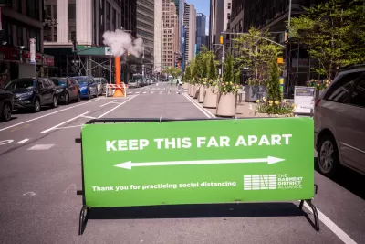
"Public space for social distancing is hard to find in many of New York City’s low-income neighborhoods," reports Clayton Guse.
That conclusion is made possible by a map published recently by the Trust for Public Land. "The map reveals inequities in Mayor de Blasio’s move to open up 30 miles of streets for pedestrians during the coronavirus pandemic," according to Guse.
The map overlays the open streets opening in New York City, overlaid on a map of walkable proximity to park and open space. "Neighborhoods like Brownsville in Brooklyn and Elmhurst in Queens contain large swaths that are more than a 10-minute walk from an open public park," explains Guse. "But parts of those neighborhoods have been left out of the city’s plan to ban cars from some streets as a relief valve for people on foot."
On May 22, a day after the TPL map was published, New York City announced 13 new miles of open streets and claimed to have the most miles of open streets of any city in the country, according to an article by Gersh Kuntzman.
FULL STORY: De Blasio’s move to open NYC street to pedestrians leaves out low-income neighborhoods, map shows

How Oakland Is Fixing its Pandemic Planning Equity Problem
The Oakland Slow Streets program, one of the most controversial developments of the early pandemic, has evolved to become the Essential Places initiative, thanks to new planning practices and a commitment to equity in Oakland, California.
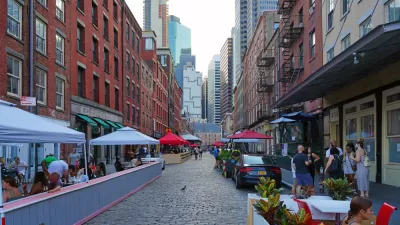
New York Outdoor Dining, Open Streets Programs Now Permanent
New York City will now be measurably less car-centric for the indefinite future.

Pandemic Planning Must Reconcile With the Inequities of the Past
The ongoing debate about the role of marginalized communities in the emergency planning programs of the pandemic has now been detailed on the pages of the New York Times.

Planetizen Federal Action Tracker
A weekly monitor of how Trump’s orders and actions are impacting planners and planning in America.

Map: Where Senate Republicans Want to Sell Your Public Lands
For public land advocates, the Senate Republicans’ proposal to sell millions of acres of public land in the West is “the biggest fight of their careers.”

Restaurant Patios Were a Pandemic Win — Why Were They so Hard to Keep?
Social distancing requirements and changes in travel patterns prompted cities to pilot new uses for street and sidewalk space. Then it got complicated.

DC Area County Eliminates Bus Fares
Montgomery County joins a growing trend of making transit free.

Platform Pilsner: Vancouver Transit Agency Releases... a Beer?
TransLink will receive a portion of every sale of the four-pack.

Toronto Weighs Cheaper Transit, Parking Hikes for Major Events
Special event rates would take effect during large festivals, sports games and concerts to ‘discourage driving, manage congestion and free up space for transit.”
Urban Design for Planners 1: Software Tools
This six-course series explores essential urban design concepts using open source software and equips planners with the tools they need to participate fully in the urban design process.
Planning for Universal Design
Learn the tools for implementing Universal Design in planning regulations.
Heyer Gruel & Associates PA
JM Goldson LLC
Custer County Colorado
City of Camden Redevelopment Agency
City of Astoria
Transportation Research & Education Center (TREC) at Portland State University
Camden Redevelopment Agency
City of Claremont
Municipality of Princeton (NJ)