


Using a wagon filled with phones, an artist in Berlin demonstrated the disconnect between data and the real world.
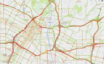
Simon Weckert is an artist who traversed the street of Berlin pulling a wagon filled with 99 smartphones connected to Google Maps. The result was a series of maps showing illusory traffic jams and congestion on roads, some of which were empty.
"The maps are their own territory, their own objective reality, not just a reflection of the real world but a branch of it. Weckert was showing us all how data and maps can affect the world they’re meant to chart," writes Matthew Gault.
In addition, data itself is not objective and Weckert’s hacking demonstrates how it can be warped and manipulated, says Gault. According to Weckert, both collecting and analyzing data are activities open to interpretation.
FULL STORY: This Man Created Traffic Jams on Google Maps Using a Red Wagon Full of Phones


The Gig Economy for Mapping
A new startup wants to use blockchain and the Uber model to create free, open-source maps.
The Growing Importance of Location Intelligence
Location intelligence is transforming decision-making, with an increasing number and type of organizations modernizing operations with a geographic approach to problem-solving, planning, and prediction.

Debunking the Myth of the Declining White Population
Media claimed that Census data showed a sharp decline in America's white population, but the widely publicized figure reflects a misunderstanding of new data collection techniques.

Planetizen Federal Action Tracker
A weekly monitor of how Trump’s orders and actions are impacting planners and planning in America.

Map: Where Senate Republicans Want to Sell Your Public Lands
For public land advocates, the Senate Republicans’ proposal to sell millions of acres of public land in the West is “the biggest fight of their careers.”

Restaurant Patios Were a Pandemic Win — Why Were They so Hard to Keep?
Social distancing requirements and changes in travel patterns prompted cities to pilot new uses for street and sidewalk space. Then it got complicated.

Platform Pilsner: Vancouver Transit Agency Releases... a Beer?
TransLink will receive a portion of every sale of the four-pack.

Toronto Weighs Cheaper Transit, Parking Hikes for Major Events
Special event rates would take effect during large festivals, sports games and concerts to ‘discourage driving, manage congestion and free up space for transit.”

Berlin to Consider Car-Free Zone Larger Than Manhattan
The area bound by the 22-mile Ringbahn would still allow 12 uses of a private automobile per year per person, and several other exemptions.
Urban Design for Planners 1: Software Tools
This six-course series explores essential urban design concepts using open source software and equips planners with the tools they need to participate fully in the urban design process.
Planning for Universal Design
Learn the tools for implementing Universal Design in planning regulations.
Heyer Gruel & Associates PA
JM Goldson LLC
Custer County Colorado
City of Camden Redevelopment Agency
City of Astoria
Transportation Research & Education Center (TREC) at Portland State University
Camden Redevelopment Agency
City of Claremont
Municipality of Princeton (NJ)