


Transit-oriented development has ramped up in Chicago, but racial and economic inequities have come along with it. A proposed ordinance would expand TOD zones while also preventing displacement of residents.

Chicago passed a transit-oriented development ordinance in 2013 as well as an initiative last year focused on TODs along high-ridership bus corridors in the city. "If a land parcel is located within a quarter-mile (two full blocks or a roughly five-minute walk) of a designated bus line segment, that parcel is eligible for reductions in required parking and increases in height and density," reports David Zegeye.
As these projects have moved forward, however, concerns about displacement in low-income communities and communities of color have become an issue, particularly in areas where upscale TOD projects mean less affordable housing. Mayor Rahm Emanuel last week introduced a new ordinance to expand the city’s TOD zones and support equitable TOD, says Zegeye:
Unlike previous versions of Chicago’s TOD ordinance, the new legislation explicitly mentions using TOD as a strategy for increasing racial and economic equity. Stated goals include "Avoiding displacement of residents, small businesses, cultural institutions, and community organizations" and "Encouraging investment in communities of color and low-income communities and appropriately addressing various market conditions."
The goal of the ordinance is to encourage TODs in underserved parts of the city, including Chicago's South Side and West Side neighborhoods. The TOD bus corridors also align with areas the city hopes to revitalize using local economic development and federal Opportunity Zone funding.
FULL STORY: How Chicago’s New Bus TOD Ordinance Could Help Underserved Communities

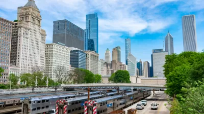
Chicago Passes Equitable TOD Ordinance
The new legislation will promote more development near transit in the city’s underserved neighborhoods and improve safety for pedestrians and other road users.
High Housing Costs Driving Down Transit Ridership in LA
When neighborhoods gentrify and displace lower-income residents, transit ridership suffers, new research shows.
Can We Resist Displacement From Transit-Oriented Development?
Transit stations increase nearby jobs and populations, but they could also contribute to displacement. What can we do differently?

Planetizen Federal Action Tracker
A weekly monitor of how Trump’s orders and actions are impacting planners and planning in America.

Map: Where Senate Republicans Want to Sell Your Public Lands
For public land advocates, the Senate Republicans’ proposal to sell millions of acres of public land in the West is “the biggest fight of their careers.”

Restaurant Patios Were a Pandemic Win — Why Were They so Hard to Keep?
Social distancing requirements and changes in travel patterns prompted cities to pilot new uses for street and sidewalk space. Then it got complicated.

Platform Pilsner: Vancouver Transit Agency Releases... a Beer?
TransLink will receive a portion of every sale of the four-pack.

Toronto Weighs Cheaper Transit, Parking Hikes for Major Events
Special event rates would take effect during large festivals, sports games and concerts to ‘discourage driving, manage congestion and free up space for transit.”

Berlin to Consider Car-Free Zone Larger Than Manhattan
The area bound by the 22-mile Ringbahn would still allow 12 uses of a private automobile per year per person, and several other exemptions.
Urban Design for Planners 1: Software Tools
This six-course series explores essential urban design concepts using open source software and equips planners with the tools they need to participate fully in the urban design process.
Planning for Universal Design
Learn the tools for implementing Universal Design in planning regulations.
Heyer Gruel & Associates PA
JM Goldson LLC
Custer County Colorado
City of Camden Redevelopment Agency
City of Astoria
Transportation Research & Education Center (TREC) at Portland State University
Camden Redevelopment Agency
City of Claremont
Municipality of Princeton (NJ)