


Accessible technology and a centralized database and call center will help deliver a one-call, one-click transportation information system for seniors and people with special needs in the Portland region.
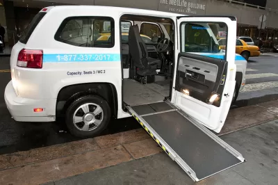
"Seniors and people living with a disability who need accessible transportation across the Portland region have dealt with a patchwork of inadequate services for years," write Catie Gould and Emily Guise. "A new initiative called Mobility for All hopes to change that by creating a one-call, one-click regional transportation information system."
Much of the improvements from Mobility for All will be implemented in operations infrastructure, rather than in fancy new vehicles. "The new initiative focuses on creating a centralized database and call center for transit resources in Multnomah, Clackamas, and Washington counties," according to the article. "At the highest level of investment, the system could provide coordinated ride booking, dispatching and payment."
According to the article, the need for improved paratransit services is growing as the region's population ages—at a rate faster than the national average. Ride Connection, a private non-profit paratransit service saw a 28 percent increase in rides between 2014 and 2016, according to the article.
FULL STORY: ‘Mobility for All’ initiative seeks to create one-stop shop for transportation access

An Unexpected Turn for California's New State Population Report
Population data released May 1 by the Department of Finance reveals the Golden State's lowest population growth rate on record, at 0.47 percent.

Do Seniors Need Cars?
One common argument against road diets and other pro-walkability policies is that seniors need cars more than anyone else. Is this claim borne out by data?

Portland's Biketown to Include 'Adaptive Bikes' to Ensure Universal Access
The city of Portland is wearing the Yellow Jersey on equity issues connected to the Biketown bikeshare system.

Planetizen Federal Action Tracker
A weekly monitor of how Trump’s orders and actions are impacting planners and planning in America.

Map: Where Senate Republicans Want to Sell Your Public Lands
For public land advocates, the Senate Republicans’ proposal to sell millions of acres of public land in the West is “the biggest fight of their careers.”

Restaurant Patios Were a Pandemic Win — Why Were They so Hard to Keep?
Social distancing requirements and changes in travel patterns prompted cities to pilot new uses for street and sidewalk space. Then it got complicated.

Albuquerque Route 66 Motels Become Affordable Housing
A $4 million city fund is incentivizing developers to breathe new life into derelict midcentury motels.

DC Area County Eliminates Bus Fares
Montgomery County joins a growing trend of making transit free.

Platform Pilsner: Vancouver Transit Agency Releases... a Beer?
TransLink will receive a portion of every sale of the four-pack.
Urban Design for Planners 1: Software Tools
This six-course series explores essential urban design concepts using open source software and equips planners with the tools they need to participate fully in the urban design process.
Planning for Universal Design
Learn the tools for implementing Universal Design in planning regulations.
Heyer Gruel & Associates PA
JM Goldson LLC
Custer County Colorado
City of Camden Redevelopment Agency
City of Astoria
Transportation Research & Education Center (TREC) at Portland State University
Camden Redevelopment Agency
City of Claremont
Municipality of Princeton (NJ)