


The Denveright plan puts pedestrians first, but could do more for public transportation and bikes, says a critique from Streetsblog Denver.

A new Streetsblog Denver series unpacks the implications of Denveright, the recently released suite of plans that together form a comprehensive vision for the city's future growth. The piece of the new package guiding land use and transportation for the next 20 years is Blueprint Denver—and at this stage, it's receiving mixed reviews from writer David Sachs.
Blueprint's revamped framework for street design calls for every street in the city to prioritize walking over other modes of transportation, and explicitly acknowledges the trade-offs that will require, like slowing vehicle speeds and reducing street parking. But it stops short of adopting a full complete streets policy by not extending public transit or bicycle infrastructure throughout the city. Sachs reports:
City planners opted against recommending a "complete streets" policy, a simple directive that compels planners and engineers to favor pedestrians, bicyclists, transit riders, and cars — in that order — on every street … Instead, Blueprint creates a more complex “modal priority” network [PDF]. Maps identify where walking should dominate (all streets), where biking is the street’s main function, and where transit is the priority. Some streets will prioritize all three modes.
As Sachs points out, many of the corridors projected to absorb a large share of new population and job growth were among those not chosen to receive bike infrastructure.
FULL STORY: Denver’s New Blueprint for Growth Puts Peds First, But Every Street Won’t Be “Complete”


The Denveright Plan Charts a 20-Year Vision
The largest planning process in Denver's history has already completed two years of community engagement and planning work.
Plan for Expanded Road Inconsistent With Denver's Values
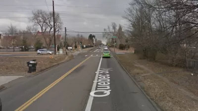
The idea of road improvement catering only to cars and congestion didn't pass muster on Quebec Street in Denver. A new plan for the heavily used, but narrow, corridor will prioritize pedestrians, safety, and transit.
Why Bike Lanes Are Good: An Explainer for the US Transportation Secretary
Sean Duffy says there’s no evidence that bike lanes have benefits. Streetsblog — and federal agencies’ own data — beg to differ.

Planetizen Federal Action Tracker
A weekly monitor of how Trump’s orders and actions are impacting planners and planning in America.

Maui's Vacation Rental Debate Turns Ugly
Verbal attacks, misinformation campaigns and fistfights plague a high-stakes debate to convert thousands of vacation rentals into long-term housing.

Restaurant Patios Were a Pandemic Win — Why Were They so Hard to Keep?
Social distancing requirements and changes in travel patterns prompted cities to pilot new uses for street and sidewalk space. Then it got complicated.

In California Battle of Housing vs. Environment, Housing Just Won
A new state law significantly limits the power of CEQA, an environmental review law that served as a powerful tool for blocking new development.

Boulder Eliminates Parking Minimums Citywide
Officials estimate the cost of building a single underground parking space at up to $100,000.

Orange County, Florida Adopts Largest US “Sprawl Repair” Code
The ‘Orange Code’ seeks to rectify decades of sprawl-inducing, car-oriented development.
Urban Design for Planners 1: Software Tools
This six-course series explores essential urban design concepts using open source software and equips planners with the tools they need to participate fully in the urban design process.
Planning for Universal Design
Learn the tools for implementing Universal Design in planning regulations.
Heyer Gruel & Associates PA
JM Goldson LLC
Custer County Colorado
City of Camden Redevelopment Agency
City of Astoria
Transportation Research & Education Center (TREC) at Portland State University
Jefferson Parish Government
Camden Redevelopment Agency
City of Claremont