


For the next several months, nine sites will be the focus of efforts to design for resilience as sea levels rise. Proposals involve "threading nature back into an urbanized terrain."
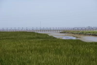
Resilient by Design's Bay Area Challenge has put ten multidisciplinary teams to work conceptualizing "a region where cities and nature are entwined more closely than ever before." Their impetus: the need to design places that can handle rising seas.
As John King writes, "The challenge, which is being funded by local governments and the Rockefeller Foundation, is modeled on New York and New Jersey’s rebuilding effort after Hurricane Sandy in 2012."
The Bay Area effort, by contrast, isn't a response to "calamitous damage." It's a bid to prepare for a gradual threat, and invites participants to reimagine how cities interact with nature. Many of the designs, King says, involve "threading nature back into an urbanized terrain, so to speak."
The challenge began with a competition last year, with the ten winning teams each receiving $250,000 for their projects. The final proposals are expected in May. "The months ahead will be spent burrowing into the specific locations, and reaching out to the surrounding communities to make sure there's widespread participation in the final proposals."
FULL STORY: Design competition tackles sites around Bay Area to address rising waters


Bay Area Developments at Risk From Sea Level Rise
A controversial proposed housing development in Newark exemplifies the struggle between increasing housing supply and protecting vulnerable shoreline communities from flooding.
Making the Bay Area Resilient By Design
The Resilient By Design Bay Area Challenge has produced nine designs to address sea-level rise and flooding around the San Francisco Bay Area.
Bay Area's First Climate Adaptation Project Could Be a North Bay Highway
State Route 37 is a vital highway connecting four North Bay counties plagued by two unrelated problems: chronic flooding during high tides and traffic congestion. Fixing the problem will set a precedent for Bay Area climate adaptation.

Planetizen Federal Action Tracker
A weekly monitor of how Trump’s orders and actions are impacting planners and planning in America.

San Francisco's School District Spent $105M To Build Affordable Housing for Teachers — And That's Just the Beginning
SFUSD joins a growing list of school districts using their land holdings to address housing affordability challenges faced by their own employees.

The Tiny, Adorable $7,000 Car Turning Japan Onto EVs
The single seat Mibot charges from a regular plug as quickly as an iPad, and is about half the price of an average EV.

Seattle's Plan for Adopting Driverless Cars
Equity, safety, accessibility and affordability are front of mind as the city prepares for robotaxis and other autonomous vehicles.

As Trump Phases Out FEMA, Is It Time to Flee the Floodplains?
With less federal funding available for disaster relief efforts, the need to relocate at-risk communities is more urgent than ever.

With Protected Lanes, 460% More People Commute by Bike
For those needing more ammo, more data proving what we already knew is here.
Urban Design for Planners 1: Software Tools
This six-course series explores essential urban design concepts using open source software and equips planners with the tools they need to participate fully in the urban design process.
Planning for Universal Design
Learn the tools for implementing Universal Design in planning regulations.
Smith Gee Studio
City of Charlotte
City of Camden Redevelopment Agency
City of Astoria
Transportation Research & Education Center (TREC) at Portland State University
US High Speed Rail Association
City of Camden Redevelopment Agency
Municipality of Princeton (NJ)