


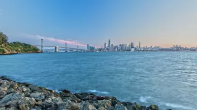
The Resilient By Design Bay Area Challenge has produced nine designs to address sea-level rise and flooding around the San Francisco Bay Area.
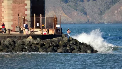
"The Resilient By Design Bay Area Challenge brought together nine multi-disciplinary design teams to develop resilient solutions to climate change-induced sea level rise and severe flooding, and seismic impacts at various sites around the San Francisco Bay," according to an article by Grace Mitchell.
The Bay Area Challenge differed from the previous iteration of Resilient By Design, which designed for New York City with funding on the line and support from the U.S. Department of Housing and urban Development.
"While there is no funding laid out to implement the Bay Area projects, several teams will continue efforts with communities to realize them," adds Mitchell. "The success of the competition lies in the ideas generated. Bay Area jurisdictions will then need to decide how, when, and what to move forward."
Mitchell examines the resulting design proposals in two articles (Part 1 and Part 2) that include project descriptions and lots of beautiful renderings.
FULL STORY: Resilient by Design Bay Area Challenge Proposals Unveiled (Part 1)

Two Coastal Areas Face Climate Change Threats, but Their Stories Are Vastly Different
In Manila and the San Francisco Bay Area, the severe impacts of rising sea levels are indisputable. But the only similarities are that both places face very uncertain futures.
Bay Area Businesses Launch Challenge to Fund Climate Resilience
A regional business association hopes to raise private funds for climate adaptation planning throughout California.
How to Fight 'Coastal Squeeze' By Engineering Nature
A Rutgers professor restores natural processes to help shorelines adapt to rising sea levels.

Planetizen Federal Action Tracker
A weekly monitor of how Trump’s orders and actions are impacting planners and planning in America.

Restaurant Patios Were a Pandemic Win — Why Were They so Hard to Keep?
Social distancing requirements and changes in travel patterns prompted cities to pilot new uses for street and sidewalk space. Then it got complicated.

Map: Where Senate Republicans Want to Sell Your Public Lands
For public land advocates, the Senate Republicans’ proposal to sell millions of acres of public land in the West is “the biggest fight of their careers.”

Maui's Vacation Rental Debate Turns Ugly
Verbal attacks, misinformation campaigns and fistfights plague a high-stakes debate to convert thousands of vacation rentals into long-term housing.

San Francisco Suspends Traffic Calming Amidst Record Deaths
Citing “a challenging fiscal landscape,” the city will cease the program on the heels of 42 traffic deaths, including 24 pedestrians.

California Homeless Arrests, Citations Spike After Ruling
An investigation reveals that anti-homeless actions increased up to 500% after Grants Pass v. Johnson — even in cities claiming no policy change.
Urban Design for Planners 1: Software Tools
This six-course series explores essential urban design concepts using open source software and equips planners with the tools they need to participate fully in the urban design process.
Planning for Universal Design
Learn the tools for implementing Universal Design in planning regulations.
Heyer Gruel & Associates PA
JM Goldson LLC
Custer County Colorado
City of Camden Redevelopment Agency
City of Astoria
Transportation Research & Education Center (TREC) at Portland State University
Camden Redevelopment Agency
City of Claremont
Municipality of Princeton (NJ)