


Due to the high level of existing congestion, the Metropolitan Transportation Commission warns motorists that the new I-680 Contra Costa Express Lanes will offer relief just before and after the peak commute hour.
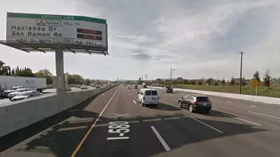
Michael Cabanatuan of the San Francisco Chronicle reports on the new high occupancy toll (HOT) lanes through the San Ramon Valley in Contra Costa County, the first express lanes to be constructed and operated by the Bay Area's metropolitan planning organization, the Metropolitan Transportation Commission (MTC).
“This is not going to eliminate congestion in the 680 corridor,” said John Goodwin of MTC. “Absolutely expect it to relieve congestion, especially ... just before and after peak travel times. But during periods of consistently very heavy traffic, during the peak, the express lanes may not move the needle a great deal."
If traffic is so heavy that the express lanes come to a slow crawl, only carpools will be allowed into the lane until the flow improves.
The lanes, converted from existing carpool lanes, stretch 11-12 miles in each direction, and will operate as express (or HOT) lanes from 5 a.m.-8 p.m., Monday through Friday, unlike Northern Virginia's I-66 lanes which will open in December as "the first rush-hour-only, peak-period toll system of its kind in the United States," as noted here on Tuesday.
Carpools, clean air vehicles, and motorcycles continue to get break
Unlike the I-66 HOT lanes, though, "clean air vehicles" will continue to use the converted high occupancy vehicle (HOV) lanes toll-free provided they have the white or green decals and a FasTrak Flex toll transponder set in the 3+ position. Carpools also will continue to operate toll-free provided they have the flex toll transponder set in either the 2 or 3+ position. Motorcycles need the flex transponder as well.
Congestion pricing will apply, with a minimum of $.50 for each of the two sections of the roadway. A maximum toll has not been set.
Network is growing
"With the addition of the 680 Contra Costa lanes, the Bay Area’s express lanes now cover 75 miles," adds Cabanatuan for The Chronicle. While these are the first lanes to be built and operated by the Bay Area Infrastructure Financing Authority, a joint powers authority between MTC and the Bay Area Toll Authority, other Bay Area express lanes fall under the authorities of the Santa Clara Valley Transportation Authority and the Alameda County Transportation Commission.
By 2035, regional transportation planners expect them to form a network that stretches 550 miles mostly in the East Bay and South Bay.
Coming next, in 2020, are express lanes on Interstate 880 between the southern tip of Oakland and Highway 237 in Milpitas and an extension of the Contra Costa lanes in the southbound direction to Marina Vista in Martinez [click on "Martinez to Walnut Creek" near the bottom of page].
Both of these projects are spearheaded by MTC. Click here for a map of the entire 550-mile Bay Area Express Lane network, with links to details for each corridor.
For more details on the I-680 Contra Costa Express Lanes, click on 511.org/driving/express-lanes/work.
Hat tip: AASHTO Daily Transportation Update.
FULL STORY: Express lanes to help ease congestion in 680 corridor

Bay Area Express Lanes Turn a Profit
Not all of them, just the I-580 lanes. One of the reasons is that most users are actually paying, unlike the other two express lanes where a majority of users are clean-air vehicles or carpools, neither of which pay.
First Bay Area Express Lanes Approved For New Bay Area Agency
The Bay Area already has express lanes - but these 23 miles in Contra Costa County on I-680 will be the first built and operated by the new Bay Area Infrastructure Financing Authority, a division of the Metropolitan Transportation Commission (MTC).
Congestion Pricing in the San Francisco Bay Area
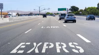
Planners call them “express lanes,” but make no mistake, they are congestion pricing in action, and they're successful. The Bay Area network of what the Federal Highway Administration calls “high-occupancy toll (HOT) lanes” is growing.

Maui's Vacation Rental Debate Turns Ugly
Verbal attacks, misinformation campaigns and fistfights plague a high-stakes debate to convert thousands of vacation rentals into long-term housing.

Planetizen Federal Action Tracker
A weekly monitor of how Trump’s orders and actions are impacting planners and planning in America.

San Francisco Suspends Traffic Calming Amidst Record Deaths
Citing “a challenging fiscal landscape,” the city will cease the program on the heels of 42 traffic deaths, including 24 pedestrians.

Defunct Pittsburgh Power Plant to Become Residential Tower
A decommissioned steam heat plant will be redeveloped into almost 100 affordable housing units.

Trump Prompts Restructuring of Transportation Research Board in “Unprecedented Overreach”
The TRB has eliminated more than half of its committees including those focused on climate, equity, and cities.

Amtrak Rolls Out New Orleans to Alabama “Mardi Gras” Train
The new service will operate morning and evening departures between Mobile and New Orleans.
Urban Design for Planners 1: Software Tools
This six-course series explores essential urban design concepts using open source software and equips planners with the tools they need to participate fully in the urban design process.
Planning for Universal Design
Learn the tools for implementing Universal Design in planning regulations.
Heyer Gruel & Associates PA
JM Goldson LLC
Custer County Colorado
City of Camden Redevelopment Agency
City of Astoria
Transportation Research & Education Center (TREC) at Portland State University
Jefferson Parish Government
Camden Redevelopment Agency
City of Claremont