


State Route 37 is a vital highway connecting four North Bay counties plagued by two unrelated problems: chronic flooding during high tides and traffic congestion. Fixing the problem will set a precedent for Bay Area climate adaptation.
The 21-mile highway, known as SR 37, connects the counties of Marin, Sonoma, Solano, and Napa while skirting the San Pablo Bay. It suffers two unrelated problems: flooding caused by high tides and traffic congestion.
Fixing the highway's problems "to avoid its potential loss in the next 20 years because of flooding will be our first regional foray into adapting to sea level rise — an issue that will threaten most of our shoreline infrastructure, coastal ecosystems and population centers," write University of California at Davis ecologist, Fraser Shilling, co-director of the Road Ecology Center, and Steven Moore, a civil engineer and vice chair of the State Water Resources Control Board, in this cover story for the Insight section of Sunday's San Francisco Chronicle.
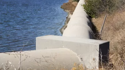
Today the highway is built atop a berm, an outdated method of building roads across marshes and waterways that constricts the ability of the bay to improve water quality by filtering out pollutants, produce more fish and wildlife, and absorb floods.
Currently, some are advocating for raising the highway [$1.3 billion] in its current location, with the primary goal of increasing traffic flows, at least in the short term. Although cheaper than the bridge-causeway alternative [$4 billion], the berm approach misses the more holistic opportunities of reconnecting marshlands to the bay and taking advantage of the flood-absorbing capacity of thousands of acres of these publicly owned wetlands.
One is reminded of the catastrophic damage done by Hurricane Harvey to Houston last month, caused in part by development choices made by the city and region. Mitigating flooding by connecting the marshes to the bay by either the causeway, which would still impact marshes, or what Shilling and Moore call the North Bay Bridge, may enable the project to tap the 2016 regional Measure AA funds for wetland restoration and adaptation to sea level rise.
Tolling an option
In 2015, the congestion management agencies of the four affected counties "agreed to form a partnership ... to develop an expedited funding, financing and project implementation strategy for the reconstruction of SR 37 to withstand rising seas and storm surges while improving mobility and safety along the route," according to the Sonoma County Transportation Authority.
A post last May indicated they are explore financing options which reportedly include the use of tolling and public-private partnerships.
FULL STORY: Rebuild State Route 37 to address sea level rise and traffic


Bay Area Developments at Risk From Sea Level Rise
A controversial proposed housing development in Newark exemplifies the struggle between increasing housing supply and protecting vulnerable shoreline communities from flooding.
Bay Area to Create Regional Plan for Sea-Level Rise
California wants the region to work together to deal with the impacts of climate change.
An In-Depth Look at Sea Level Rise in the San Francisco Bay Area
The San Francisco Chronicle gives feature-length, in-depth treatment to the looming dangers of sea level rise, which are more likely to encroach on the built and natural environments of the Bay Area with every passing year.

Maui's Vacation Rental Debate Turns Ugly
Verbal attacks, misinformation campaigns and fistfights plague a high-stakes debate to convert thousands of vacation rentals into long-term housing.

Planetizen Federal Action Tracker
A weekly monitor of how Trump’s orders and actions are impacting planners and planning in America.

In Urban Planning, AI Prompting Could be the New Design Thinking
Creativity has long been key to great urban design. What if we see AI as our new creative partner?

California Creates Housing-Focused Agency
Previously, the state’s housing and homelessness programs fell under a grabbag department that also regulates the alcohol industry, car mechanics, and horse racing.

Chicago’s Ghost Rails
Just beneath the surface of the modern city lie the remnants of its expansive early 20th-century streetcar system.

Baker Creek Pavilion: Blending Nature and Architecture in Knoxville
Knoxville’s urban wilderness planning initiative unveils the "Baker Creek Pavilion" to increase the city's access to green spaces.
Urban Design for Planners 1: Software Tools
This six-course series explores essential urban design concepts using open source software and equips planners with the tools they need to participate fully in the urban design process.
Planning for Universal Design
Learn the tools for implementing Universal Design in planning regulations.
planning NEXT
Appalachian Highlands Housing Partners
Mpact (founded as Rail~Volution)
City of Camden Redevelopment Agency
City of Astoria
City of Portland
City of Laramie