


The Guardian's former environmental editor asks if urban sprawl is as much to blame as climate change for the flooding caused by Hurricane Harvey in Houston.
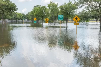
As of Sept. 5, the death toll caused by Hurricane Harvey, which made landfall near Corpus Christi, Texas on August 25, was 60 according to The Washington Post. In South Asia, over 1,400 people lost their lives to unusually powerful monsoons. John Vidal, the Guardian's former environmental editor, points to Africa which has also recently experienced great loss of life due to monster storms.
"So what is to blame for these severe weather events and some of the worst flooding ever seen?" he asks.
Climate scientists agree that extreme rainfall will increase as the world warms. Other researchers argue that poor urban infrastructure and the rapid, unchecked sprawl of cities on to marshlands and other places that usually absorb excess rainwater have led to flooding.
“We know climate change is influencing the capacity of the atmosphere to hold water but it is hard to attribute this to individual [flooding] events,” says Paolo Ruti, head of the global weather research division of the UN’s World Meteorological Organisation (WMO) in Geneva.
No such reservations on the cause of the extreme flooding experienced by Housto are held by Sam Brody, a Texas A&M University marine researcher with a Ph.D. in City and Regional Planning, University of North Carolina, Chapel Hill, who specialises in natural hazards. Brody was also interviewed by CityLab in our first post on Harvey.
[He] believes the addition of more than 1 million people moving to flood-prone areas near Houston since 2000 has overwhelmed the city’s ability to drain water.
The Texas coastal climate is changing, the sea level is rising and there are more heavy downpours, says Brody, but the key factor in the flooding is development in unsuitable areas.
“If you are going to put 4 million people in this flood-vulnerable area in a way which involves ubiquitous application of impervious surfaces, you’re going to get flooding. The driving force is the built environment,” he says.
Billy Fleming, research director for the Ian L McHarg Center at the University of Pennsylvania School of Design, where he earned a PhD in City Planning, writing for the Guardian casts blame on people as well as policies.
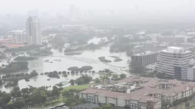
Houston’s unfettered sprawl into the marshland of southeast Texas was a conscious choice by policymakers...The swamps and wetlands that once characterized Houston’s hinterland have been replaced with strip malls and suburban tract homes.
Those landscapes once served as a natural flood protection system for the city. Research shows that, if they hadn’t been filled and developed, Harvey’s impact would have been lessened. Sam Brody and his colleagues at Texas A&M University in Galveston have been predicting an event like this for nearly a decade. That their work went unheeded by Texas policymakers should not be forgotten.
An earlier post looked at how Houston's lack of zoning may have contributed to the flooding. Researchers instead found fault with sprawling development patterns and a lack of regional planning.
"In Harris County alone, research by Texas A&M scientist John Jacob shows, almost 30 percent of freshwater wetlands were lost between 1992 and 2010, a figure he calls 'unconscionable.'" [ProPublica: "Boom town, flood town: How Houston's development increases flood risk," Dec. 7, 2016]
As for the category 5, Hurricane Irma, packing 185-mph winds, CNN reports on Wednesday that it has destroyed "nearly 90% of Barbuda", located in the middle of the Leeward Islands in the Caribbean. And what of it coming just days after the category 4 Hurricane (now tropical depression) Harvey?
Ruti of the WMO adds, “The frequency of hurricanes and tropical storms is not changing, but we must get more and more used to these events.”
Hat tip to Fred Heutte.
FULL STORY: As flood waters rise, is urban sprawl as much to blame as climate change?

The Culprit of Houston Flooding: Sprawl, Not Lack of Zoning
As Houston's flood waters recede and attention turns from rescue to recovery and soon rebuilding, critics have pointed to the city's lack of zoning as the cause of the devastation. But are they looking in the right direction?
When Coastal States Kill Building Codes, FEMA Pays
Despite the increasing number and intensity of natural disasters, some vulnerable states are relaxing building regulations and leaving the federal government to pick up the tab when tragedy strikes again.

Challenges in Rebuilding Houston Extend Beyond Development
Michael Kimmelman, architecture critic of The New York Times, looks beyond sprawl and development issues that challenge Houston in its rebuilding efforts. An anti-urban, anti-regulation bias from the statehouse isn't helping matters.

Maui's Vacation Rental Debate Turns Ugly
Verbal attacks, misinformation campaigns and fistfights plague a high-stakes debate to convert thousands of vacation rentals into long-term housing.

Planetizen Federal Action Tracker
A weekly monitor of how Trump’s orders and actions are impacting planners and planning in America.

In Urban Planning, AI Prompting Could be the New Design Thinking
Creativity has long been key to great urban design. What if we see AI as our new creative partner?

King County Supportive Housing Program Offers Hope for Unhoused Residents
The county is taking a ‘Housing First’ approach that prioritizes getting people into housing, then offering wraparound supportive services.

Researchers Use AI to Get Clearer Picture of US Housing
Analysts are using artificial intelligence to supercharge their research by allowing them to comb through data faster. Though these AI tools can be error prone, they save time and housing researchers are optimistic about the future.

Making Shared Micromobility More Inclusive
Cities and shared mobility system operators can do more to include people with disabilities in planning and operations, per a new report.
Urban Design for Planners 1: Software Tools
This six-course series explores essential urban design concepts using open source software and equips planners with the tools they need to participate fully in the urban design process.
Planning for Universal Design
Learn the tools for implementing Universal Design in planning regulations.
planning NEXT
Appalachian Highlands Housing Partners
Mpact (founded as Rail~Volution)
City of Camden Redevelopment Agency
City of Astoria
City of Portland
City of Laramie