


The city of San Jose has a mixed record of moving forward with land use changes that complement its existing and expanding transit systems.
"The Santa Clara Valley Transportation Authority has pulled plans for now to build a high-density, mixed-use project near the Branham light rail station," reports Julia Baum.
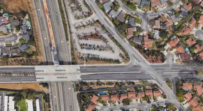
"In March the VTA asked San Jose officials to amend the city’s General Plan so it could develop a 3-acre parcel at 4747 Narvaez Ave., which currently serves as the agency’s parking lot," adds Baum. Any plans to redevelop the parking lot will have to wait, and the VTA is saying it is waiting for a traffic study on Highway 87. The nearby Highway 87/Capitol Expressway/Narvaez on-ramp is notoriously congested, and "[p]revious development proposals have met with resistance from neighbors who felt area traffic and parking problems were ignored."
The setback for the proposed development breaks a hot streak for transit oriented development in the city of San Jose. Development proposals have moved forward in recent months at the future Berryessa Station and at the soon-to-be-expanded Diridon Station.
FULL STORY: VTA pulls plans to build near Branham light rail

San Jose's Measure B Transportation Funding Caught in Legal Dispute
A one-woman crusade in San Jose, California has derailed transportation spending enabled by the voter approved funding package of Measure B.
A Planning Controversy of the Transit Oriented Variety in Suburban Denver
A controversy has erupted over a proposed vision for transit oriented mixed in a Denver suburb.
San Jose Rail Extension Clinches Final Funding Piece
The new line will expand rail service to more communities in the South Bay.

Planetizen Federal Action Tracker
A weekly monitor of how Trump’s orders and actions are impacting planners and planning in America.

Maui's Vacation Rental Debate Turns Ugly
Verbal attacks, misinformation campaigns and fistfights plague a high-stakes debate to convert thousands of vacation rentals into long-term housing.

Restaurant Patios Were a Pandemic Win — Why Were They so Hard to Keep?
Social distancing requirements and changes in travel patterns prompted cities to pilot new uses for street and sidewalk space. Then it got complicated.

In California Battle of Housing vs. Environment, Housing Just Won
A new state law significantly limits the power of CEQA, an environmental review law that served as a powerful tool for blocking new development.

Boulder Eliminates Parking Minimums Citywide
Officials estimate the cost of building a single underground parking space at up to $100,000.

Orange County, Florida Adopts Largest US “Sprawl Repair” Code
The ‘Orange Code’ seeks to rectify decades of sprawl-inducing, car-oriented development.
Urban Design for Planners 1: Software Tools
This six-course series explores essential urban design concepts using open source software and equips planners with the tools they need to participate fully in the urban design process.
Planning for Universal Design
Learn the tools for implementing Universal Design in planning regulations.
Heyer Gruel & Associates PA
JM Goldson LLC
Custer County Colorado
City of Camden Redevelopment Agency
City of Astoria
Transportation Research & Education Center (TREC) at Portland State University
Jefferson Parish Government
Camden Redevelopment Agency
City of Claremont