


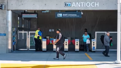
In 1995, planners forecasted that the Millbrae BART Station in San Mateo County, where riders can transfer to/from Caltrain, would attract 16,500 weekday riders. Fourteen years after it opened, ridership is 7,000. Planners were off by 58 percent.
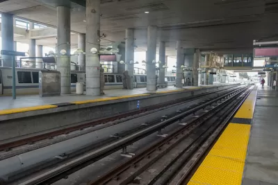
The Millbrae Station was part of a five-station extension from Daly City, then the southern terminal of the Bay Area Rapid Transit system located just south of San Francisco in San Mateo County, to Millbrae and the San Francisco International Airport (SF0). The extension opened in June 2003.

Credit: Bay Area Rapid Transit District
Among the reasons that BART offers to explain why the projection was so wildly off-base, reported by Michael Cabanatuan for the San Francisco Chronicle:
- Economic: Projections were made in booming era in 1995; the extension opened in 2003 during dot-com bust.
- Issues pertaining to Caltrain–BART transfer. At one point, the plan was to make the Millbrae Station the northernmost on the San Francisco-San Jose commuter line, forcing transfers between the two systems.
- Lack of transit-oriented-development, although that is changing with a TOD proposal "with 376 units of housing, a 150-room hotel, and office and retail space is planned on land next to the station."
On that last bullet, letter-writer Felicia Charles of Millbrae comments:
The low ridership at BART’s Millbrae Station is no surprise. City planners have been talking for almost 20 years about developing the area around the station for mixed residential and commercial use.
Millbrae would be more than just a place for riders to make transfers between Caltrain and BART — a true bustling transit — if such development had already occurred...
Problems abound for the Caltrain-BART transfer, mainly due to the Caltrain schedule, which can be limited to one train an hour depending on the time of day. But it was unrealistic to think that most San Francisco-bound Caltrain commuters would transfer to BART for a longer trip with more stops to San Francisco, notwithstanding Caltrain's distant terminal from Market Street in downtown San Francisco, which BART serves with several stops.
Politics beats out Planning
What's not mentioned by Cabanatuan was the role that politics played, particularly by a former San Francisco supervisor and then-state senator Quentin Kopp, who was determined to see BART go directly to San Francisco International Airport at a stub station, rather than to a shared Caltrain-BART-SFO AirTrain station.
“If the SFO extension does not go directly into the airport people will simply not use it," stated Kopp. "People will not use a system that requires them to transfer.” [September 1990; page 9 of MIT study below].
What Kopp didn't say is that upon arrival in the airport, almost all passengers would need to transfer to the SFO AirTrain to get to their terminal.
The "politics over planning" outcome is laid out in two academic papers on the BART to SFO extension:
- Massachusetts Institute of Technology: A BART-SFO Extension [pdf] by John Wenzel. December 10, 2013
- Mineta Transportation Institute: Case Study Report: San Francisco International Airport Bart Extension [pdf] by Dennis Freeman, Wenbin Wei, Ph.D. and Geoffrey D. Gosling, Ph.D. May 2012
The two-stops vs. one stop decision came down to two San Francisco local ballot measures in June 1994, writes MIT's Wenzel.
What San Francisco voters were not aware of with the Measure I ballot was that extra track and an extra station to the south of SFO in Millbrae would also have to be built adding over $500 million to the total project costs with negligible gain in ridership.
Fortunately, not all ridership forecasts are so wildly wrong. Consider L.A. Metro's extension of the Expo Line to Santa Monica which opened in May of last year. This month ridership reached the 2030 projection.
Hat tip to Margaret Okuzumi.
FULL STORY: Millbrae BART Station ridership isn’t near original expectations

Op-Ed: To Survive, Bay Area Transit Needs Integration
Advocates for ‘seamless’ transit are calling on California state leaders to tie a consolidation study to a one-time injection of funding into the Bay Area’s transit systems.
Compromise Reached to Save Caltrain
The saga of the three-county sales tax upon which the future of Caltrain depends is now in the hands of voters.
Plan to Save Caltrain Emerges
Elected officials in San Francisco and Santa Clara counties have produced a counter proposal after killing a proposed sales tax last week.

Maui's Vacation Rental Debate Turns Ugly
Verbal attacks, misinformation campaigns and fistfights plague a high-stakes debate to convert thousands of vacation rentals into long-term housing.

Planetizen Federal Action Tracker
A weekly monitor of how Trump’s orders and actions are impacting planners and planning in America.

In Urban Planning, AI Prompting Could be the New Design Thinking
Creativity has long been key to great urban design. What if we see AI as our new creative partner?

King County Supportive Housing Program Offers Hope for Unhoused Residents
The county is taking a ‘Housing First’ approach that prioritizes getting people into housing, then offering wraparound supportive services.

Researchers Use AI to Get Clearer Picture of US Housing
Analysts are using artificial intelligence to supercharge their research by allowing them to comb through data faster. Though these AI tools can be error prone, they save time and housing researchers are optimistic about the future.

Making Shared Micromobility More Inclusive
Cities and shared mobility system operators can do more to include people with disabilities in planning and operations, per a new report.
Urban Design for Planners 1: Software Tools
This six-course series explores essential urban design concepts using open source software and equips planners with the tools they need to participate fully in the urban design process.
Planning for Universal Design
Learn the tools for implementing Universal Design in planning regulations.
planning NEXT
Appalachian Highlands Housing Partners
Mpact (founded as Rail~Volution)
City of Camden Redevelopment Agency
City of Astoria
City of Portland
City of Laramie