


The California Environmental Quality Act-mandated review process for a proposed bus rapid transit project in San Francisco took 13 years to complete.

"Late Thursday, the San Francisco County Transportation Authority Board approved the final environmental review of the Geary Bus Rapid Transit project, clearing a key hurdle for the project to move forward," reports Joe Fitzgerald Rodriguez.
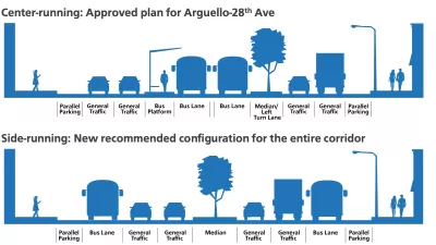
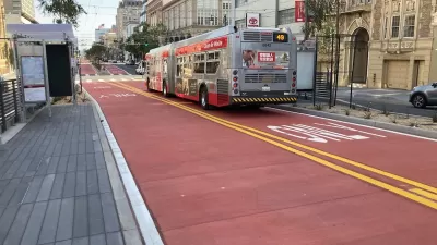
The project would transform Geary Boulevard to make the 38-Geary bus faster, and behave more like a train. A red bus-only lane would run along the sides of Geary Boulevard from 34th to 26th avenues, and the center of Geary Boulevard from 26th Avenue to just past Arguello Boulevard, and then again on the sides of Geary Boulevard the rest of the way to Market Street.
Despite the well-documented environmental benefits of bus transit, it took 13 years to complete the environmental review process for the bus project. The 38-Geary line will save an estimated 55,000 daily riders 20 minutes per round trip. The article includes the testimony from members of the public who opposed the project, and wanted to delay the vote to approve the environmental review even further.
Planning for project is not yet complete, however. According to the article, "the project will move into further planning stages under the auspices of the San Francisco Municipal Transportation Agency, requiring approvals from that agency’s board."
FULL STORY: Transit officials approve key milestone for Geary bus project

New Bus Only Lane Overcomes Opposition in San Francisco
Local business owners and the local elected official opposed the Geary transit-only lane project, but compromise and wide public support got the project across the finish line.
San Francisco’s Muni Ridership Grew in 2024
The system saw its highest ridership since before the Covid-19 pandemic, but faces a severe budget shortage in the coming year.
Van Ness BRT Speeds Travel by 36%, Earns Silver Designation
The San Francisco rapid bus line is making transit on the corridor more reliable and reducing traffic crashes and congestion.

Planetizen Federal Action Tracker
A weekly monitor of how Trump’s orders and actions are impacting planners and planning in America.

Congressman Proposes Bill to Rename DC Metro “Trump Train”
The Make Autorail Great Again Act would withhold federal funding to the system until the Washington Metropolitan Area Transit Authority (WMATA), rebrands as the Washington Metropolitan Authority for Greater Access (WMAGA).

DARTSpace Platform Streamlines Dallas TOD Application Process
The Dallas transit agency hopes a shorter permitting timeline will boost transit-oriented development around rail stations.

Parks: Essential Community Infrastructure — and a Smart Investment
Even during times of budget constraint, continued investment in parks is critical, as they provide proven benefits to public health, safety, climate resilience, and community well-being — particularly for under-resourced communities.

Porches, Pets, and the People We Grow Old With
Neighborhood connections and animal companions matter to aging with dignity, and how we build can support them. Here’s a human-scale proposal for aging in place.

Single-Stair Design Contest Envisions Human-Scale Buildings
Single-stair building construction is having a resurgence in the United States, where, for the last several decades, zoning codes have required more than one staircase in multi-story housing developments.
Urban Design for Planners 1: Software Tools
This six-course series explores essential urban design concepts using open source software and equips planners with the tools they need to participate fully in the urban design process.
Planning for Universal Design
Learn the tools for implementing Universal Design in planning regulations.
City of Charlotte
Municipality of Princeton
City of Camden Redevelopment Agency
City of Astoria
Transportation Research & Education Center (TREC) at Portland State University
US High Speed Rail Association
City of Camden Redevelopment Agency
Municipality of Princeton (NJ)