


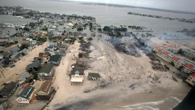
A report from the Regional Plan Association maps out what might happen under 1, 3, and 6 feet of sea level rise. In the worst cases, several dense and populated regions are affected.
Using methodology developed by the National Oceanic and Atmospheric Administration, RPA's study "outlines the impact that 1, 3 and 6 feet of sea level rise could have on the [New York] region and the immediate actions that policymakers and residents should take to protect our region's most vulnerable places."
While beach communities along Long Island and the Jersey Shore often come to mind, flooding could impact populated areas throughout greater New York. Emily Thenhaus writes, "The communities of the Rockaways, Jamaica Bay and Coney Island are among the most threatened in New York City. With 6 feet of sea level rise, a possibility as soon as early next century, much of the Rockaway peninsula could be underwater."
Rising seas may also threaten the New Jersey Meadowlands if steps aren't taken. JFK airport is mostly protected from the brunt of the floods, but LaGuardia's runways are vulnerable.
There's more to come from RPA on the region's environmental future. "The study is a component of RPA's fourth regional plan, which will be released in 2017 and will put forth policies and proposals to mitigate climate change and confront its effects."
FULL STORY: Under Water: How Sea Level Rise Threatens the Tri-State Region

Life With Climate Change: A 100-Year Storm Every Year
The extreme weather events and sea-level rise of the relatively near future will overwhelm storm and flood infrastructure with startling regularity, according to new research.

New York Flood Control Plan Takes Lessons From the Dutch
The Netherlands has a long history of flood mitigation. U.S. cities, threatened by coastal flooding and erosion, are taking note.

Opinion: One Solution to Manhattan's Land Shortage: Just Build It
A New York Times op-ed calls on the city to add landfill development on Manhattan's southern shoreline, claiming it would increase affordability and protect the city from rising sea levels.

Planetizen Federal Action Tracker
A weekly monitor of how Trump’s orders and actions are impacting planners and planning in America.

Restaurant Patios Were a Pandemic Win — Why Were They so Hard to Keep?
Social distancing requirements and changes in travel patterns prompted cities to pilot new uses for street and sidewalk space. Then it got complicated.

Map: Where Senate Republicans Want to Sell Your Public Lands
For public land advocates, the Senate Republicans’ proposal to sell millions of acres of public land in the West is “the biggest fight of their careers.”

Maui's Vacation Rental Debate Turns Ugly
Verbal attacks, misinformation campaigns and fistfights plague a high-stakes debate to convert thousands of vacation rentals into long-term housing.

San Francisco Suspends Traffic Calming Amidst Record Deaths
Citing “a challenging fiscal landscape,” the city will cease the program on the heels of 42 traffic deaths, including 24 pedestrians.

California Homeless Arrests, Citations Spike After Ruling
An investigation reveals that anti-homeless actions increased up to 500% after Grants Pass v. Johnson — even in cities claiming no policy change.
Urban Design for Planners 1: Software Tools
This six-course series explores essential urban design concepts using open source software and equips planners with the tools they need to participate fully in the urban design process.
Planning for Universal Design
Learn the tools for implementing Universal Design in planning regulations.
Heyer Gruel & Associates PA
JM Goldson LLC
Custer County Colorado
City of Camden Redevelopment Agency
City of Astoria
Transportation Research & Education Center (TREC) at Portland State University
Camden Redevelopment Agency
City of Claremont
Municipality of Princeton (NJ)