


The Red River Diversion project, also known as the Fargo-Moorhead Flood Risk Management project, has full federal approval but was recently denied a critical permit by the state. This op-ed questions the wisdom of the state's action.
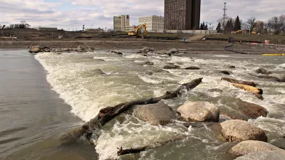
Nick Sortland opines about the Red River Diversion, "a project designed by the Army Corps of Engineers’ St. Paul office, funded by Congress and signed off by the Obama administration to allow the Fargo metropolitan area permanent flood protection from the increasingly unpredictable Red River."
According to Sortland, climate change has led to extreme and unpredictable flooding on the Red River, precipitating the need for the diversion project in and around the city. The diversion channel, according to Sortland, would also wall off the footprint for Fargo's potential sprawl.
Despite the federal approvals and the environmental case for the project, however, the Minnesota Department of Natural Resources denied a permit application for the proposed project, which it calls the Fargo-Moorhead Flood Risk Management project. The state cited three primary reasons for the denial:
- Because the land protected would rural and sparsely developed, the "project does not meet the requirement to be reasonable, practical, protect public safety and promote public welfare."
- "The project is not consistent with some state and local land use and water management plans in the project area."
- "Mitigation, monitoring and adaptive management needs remain that have not been sufficiently addressed."
Returning to the original argument in favor of the project, Sortland claims that historic precedent, climate change science, and the area's ongoing growth demand that the project move forward.
FULL STORY: Why Minnesota should support, not obstruct, Fargo-Moorhead’s permanent flood protection


How US Communities Are Building Resilience Against Flooding
Flooding causes over $400 billion in damage in the United States every year.
Planning for Future Floods
New climate and flood models are needed to understand growing flood risks.

Advancing Sustainability and Resilience Through Parks
The Urban Land Institute offers fact sheets describing five innovative ways that parks can reduce carbon emissions and mitigate climate threats while advancing health, equity, and quality of life in urban areas.

Planetizen Federal Action Tracker
A weekly monitor of how Trump’s orders and actions are impacting planners and planning in America.

Map: Where Senate Republicans Want to Sell Your Public Lands
For public land advocates, the Senate Republicans’ proposal to sell millions of acres of public land in the West is “the biggest fight of their careers.”

Restaurant Patios Were a Pandemic Win — Why Were They so Hard to Keep?
Social distancing requirements and changes in travel patterns prompted cities to pilot new uses for street and sidewalk space. Then it got complicated.

Platform Pilsner: Vancouver Transit Agency Releases... a Beer?
TransLink will receive a portion of every sale of the four-pack.

Toronto Weighs Cheaper Transit, Parking Hikes for Major Events
Special event rates would take effect during large festivals, sports games and concerts to ‘discourage driving, manage congestion and free up space for transit.”

Berlin to Consider Car-Free Zone Larger Than Manhattan
The area bound by the 22-mile Ringbahn would still allow 12 uses of a private automobile per year per person, and several other exemptions.
Urban Design for Planners 1: Software Tools
This six-course series explores essential urban design concepts using open source software and equips planners with the tools they need to participate fully in the urban design process.
Planning for Universal Design
Learn the tools for implementing Universal Design in planning regulations.
Heyer Gruel & Associates PA
JM Goldson LLC
Custer County Colorado
City of Camden Redevelopment Agency
City of Astoria
Transportation Research & Education Center (TREC) at Portland State University
Camden Redevelopment Agency
City of Claremont
Municipality of Princeton (NJ)