


Those who promote safe streets often complain of streets that are too wide, wasting space and promoting reckless speeds. In chilly Calgary, undisturbed snow shows just how much street area is completely unused.
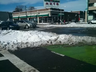
In a short compelling piece for his blog, Sneckdown Calgary, Matthew Worona illustrates how untouched snow can show where street space is going totally unused—the formation known as a sneckdown. Snow can serve as evidence of how much of the road next to the curb goes untouched and, to a lesser extent, how often people turn in each direction. "Looking more specifically at the turn lanes there is potential that these are justified even if the road is significantly under capacity. If there are a huge number of turns made maybe the slip lanes are necessary. While the tracks in the snow show little use of all but one of the slip lanes I went looking for numbers," Worona writes.
It's not the first time the argument's been made. But it's worth the seasonal reminder of how lane widths can influence speed and safety of streets. Looking at the unused space, it's easy to think what could be done with the additional curb space, whether it's more room for sidewalks, trees, cafés, or awnings, or reducing the amount of time it takes a pedestrian to cross the street. That's useful space that's being wasted on empty asphalt.
FULL STORY: 8TH ST. AND ROYAL AVE. SW


The Pandemic Offers a Chance to Rethink the Mobility Priorities of Cities
Cities have an opportunity to make bold changes that would give pedestrians and cyclists the space on streets that they deserve.

Portland Bike Lanes and the Danger of Half-Measures
Willamette's new bike lanes make for an important link in Portland's bike infrastructure, but building unprotected bike lanes on a high-speed street carries risk.

Remaking the Streets of Milwaukee for Bikes and a Changing Population
The city of Milwaukee is repairing its streets and making them more bike and pedestrian friendly in the process.

Planetizen Federal Action Tracker
A weekly monitor of how Trump’s orders and actions are impacting planners and planning in America.

San Francisco's School District Spent $105M To Build Affordable Housing for Teachers — And That's Just the Beginning
SFUSD joins a growing list of school districts using their land holdings to address housing affordability challenges faced by their own employees.

The Tiny, Adorable $7,000 Car Turning Japan Onto EVs
The single seat Mibot charges from a regular plug as quickly as an iPad, and is about half the price of an average EV.

Seattle's Plan for Adopting Driverless Cars
Equity, safety, accessibility and affordability are front of mind as the city prepares for robotaxis and other autonomous vehicles.

As Trump Phases Out FEMA, Is It Time to Flee the Floodplains?
With less federal funding available for disaster relief efforts, the need to relocate at-risk communities is more urgent than ever.

With Protected Lanes, 460% More People Commute by Bike
For those needing more ammo, more data proving what we already knew is here.
Urban Design for Planners 1: Software Tools
This six-course series explores essential urban design concepts using open source software and equips planners with the tools they need to participate fully in the urban design process.
Planning for Universal Design
Learn the tools for implementing Universal Design in planning regulations.
Smith Gee Studio
City of Charlotte
City of Camden Redevelopment Agency
City of Astoria
Transportation Research & Education Center (TREC) at Portland State University
US High Speed Rail Association
City of Camden Redevelopment Agency
Municipality of Princeton (NJ)