


Just as Toronto's subway cars provide an example of the benefits that await New Yorkers when their new 'open gangway' cars arrive in 2020, Toronto's extensive streetcar network also provides an example for New York — of what not to do.
In August, Emma G. Fitzsimmons, transit reporter at The New York Times, reported from Toronto on the open-end subway cars that have been in operation for almost five years, in preparation for the arrival of similar cars in New York as part of an ambitious $27-billion design overhaul.
The purpose of her latest report is take back lessons for the new 16-mile streetcar line planned for Brooklyn and Queens known as the Brooklyn Queens Connector (BQX). It's not by coincidence that "New York City hired Adam Giambrone, a former chairman of the Toronto Transit Commission, to run the project and sell the concept to residents along the line," writes Fitzsimmons. The line should open by 2024. And the lessons apply equally to any city planning streetcar lines.
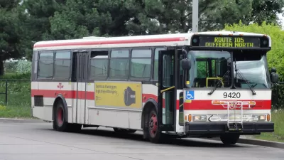
Her new report from Canada's most populous city is about North America's largest, most heavily used and second oldest streetcar network, composed of 11 routes with a daily ridership of 285,000. Total network length (2016) is 83 km (51 miles), dating back to the horsedrawn era in 1861. Only the New Orleans St. Charles line is older.
Unlike the open gangway subway cars, which received an uncategorical A+ grade by Torontonians, streetcars were disliked by many, though it wasn't the cars but the routes. More specifically, the routes that lacked dedicated lanes, generally designated by raised curbs separating them from the adjacent mixed-traffic lanes.
"As New York works to complete a rigorous study of the [BQX] line by the fall, streetcar riders and transit experts in Toronto have repeated the same two warnings: build dedicated lanes to keep the streetcars from getting trapped in traffic and be prepared for outrage over the loss of street space and parking," reports Fitzsimmons. Transit expert Yonah Freemark had tweeted the same warnings in an April Planetizen post.
Mr. Giambrone, who is living near the proposed streetcar corridor on the border of Downtown Brooklyn and Fort Greene, seemed to understand the challenges ahead and was enthusiastic to begin. He said he had already walked the corridor and envisioned several rounds of public meetings.
He said he understood how frustrating it was when streetcars in Toronto were stuck in traffic, adding that the New York line would be “heavily reliant” on a dedicated right of way. In fact, city officials have said they want more than 70 percent of the line to have its own lane — a configuration more common on light rail systems like the Hudson-Bergen Light Rail in New Jersey.
More streetcar information:
- Toronto Transportation Commission: Streetcar Network
- On why Toronto's network flourished while others died, see Planetizen Debate: Why Did Trams Die in the 20th Century? July 1, 2016
- For a comparison among the nine, first generation, or legacy streetcars and also among the eight, modern, second-generation streetcar systems, scroll way down Wikipedia's "Streetcars in North America" to see the first two tables.
Hat tip to David Orr.
FULL STORY: Toronto’s Transit Advice for New York: Give Streetcars Their Own Lanes

Speculation Continues on the Death of the Brooklyn-Queens Streetcar
The New York Times transit reporter looks into the lack of progress on the $2.5 billion project proposed by Mayor Bill de Blasio in his 2016 State of the City speech. The mayor responds angrily to a Daily News article casting doubt on the project.
Toronto Could Give Buses and Streetcars Priority
In a shift away from subway expansions and upgrades, Toronto looks to improve the bus and streetcar systems.
Brooklyn-Queens Connector Streetcar Plans Released
Plans for the Brooklyn-Queens Connector, otherwise known as the BQX, are still on the table, despite reports of the project's demise.

Planetizen Federal Action Tracker
A weekly monitor of how Trump’s orders and actions are impacting planners and planning in America.

San Francisco's School District Spent $105M To Build Affordable Housing for Teachers — And That's Just the Beginning
SFUSD joins a growing list of school districts using their land holdings to address housing affordability challenges faced by their own employees.

The Tiny, Adorable $7,000 Car Turning Japan Onto EVs
The single seat Mibot charges from a regular plug as quickly as an iPad, and is about half the price of an average EV.

Trump Approves Futuristic Automated Texas-Mexico Cargo Corridor
The project could remove tens of thousands of commercial trucks from roadways.

Austin's First Single Stair Apartment Building is Officially Underway
Eliminating the requirement for two staircases in multi-story residential buildings lets developers use smaller lots and more flexible designs to create denser housing.

Atlanta Bus System Redesign Will Nearly Triple Access
MARTA's Next Gen Bus Network will retool over 100 bus routes, expand frequent service.
Urban Design for Planners 1: Software Tools
This six-course series explores essential urban design concepts using open source software and equips planners with the tools they need to participate fully in the urban design process.
Planning for Universal Design
Learn the tools for implementing Universal Design in planning regulations.
Smith Gee Studio
City of Charlotte
City of Camden Redevelopment Agency
City of Astoria
Transportation Research & Education Center (TREC) at Portland State University
US High Speed Rail Association
City of Camden Redevelopment Agency
Municipality of Princeton (NJ)