


The Regional Plan Association presents the details of a plan to build a rail line connecting the Bronx, Queens, and Brooklyn: the Triboro Line.
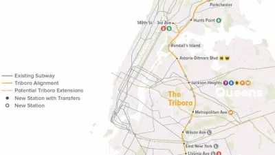
A recent policy brief shares the most recent analysis by the Regional Planning Association (RPA) into the Triboro Line proposal—a circumferential transit line connecting the three New York City boroughs of Brooklyn, Queens, and the Bronx, with a possible extension to Staten Island as well.
The brief begins by establishing the need for the project:
The majority of people living in the four boroughs outside Manhattan don’t use public transit to travel to work within the boroughs, even though they live in the city with the largest subway and bus network in the U.S. Why? Because New York City’s subways were designed to bring people into Manhattan, not to move them between other boroughs, and the buses that serve the boroughs are slow and unreliable.
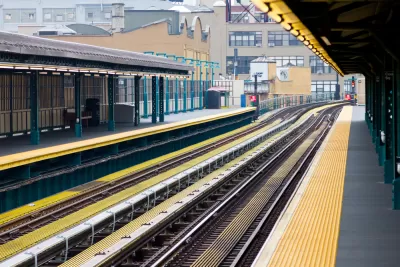
According to the RPA brief, the Triboro Line could potentially offer "fast, convenient and direct transit connection" between the Bronx, Queens, and Brooklyn. The RPA first proposed the idea in A Region at Risk: The Third Regional Plan for the New York-New Jersey-Connecticut Metropolitan Area as an above-ground line, planned to take advantage of underused and abandoned rights-of-way.
The paper includes presents the case for the line, using infographics and lots of data to back up its argument, including why the proposal relies on rail and how it would mix passenger and freight rail along its 24-mile route.
FULL STORY: The Triboro: Transit for the Boroughs

The Triboro Line Has New Life as the 'Interborough Express'
A proposed transit line that would connect three New York City boroughs not named Manhattan has new, powerful political support.

Regional Plan Association Hits Reset on Hudson Crossing Crisis
The projects proposed by a new report from the Regional Planning Association offer a preview of the Fourth Regional Plan, expected for public release in November 2017.
Design Competition Yields a New Look for the Proposed Triboro Transit Line
The design proposal for the Triboro Corridor is speculative, but meant to inspire the conversation on one of the "4c" ideas at the heart of the Regional Plan Association's Fourth Regional Plan.

Planetizen Federal Action Tracker
A weekly monitor of how Trump’s orders and actions are impacting planners and planning in America.

San Francisco's School District Spent $105M To Build Affordable Housing for Teachers — And That's Just the Beginning
SFUSD joins a growing list of school districts using their land holdings to address housing affordability challenges faced by their own employees.

The Tiny, Adorable $7,000 Car Turning Japan Onto EVs
The single seat Mibot charges from a regular plug as quickly as an iPad, and is about half the price of an average EV.

Seattle's Plan for Adopting Driverless Cars
Equity, safety, accessibility and affordability are front of mind as the city prepares for robotaxis and other autonomous vehicles.

As Trump Phases Out FEMA, Is It Time to Flee the Floodplains?
With less federal funding available for disaster relief efforts, the need to relocate at-risk communities is more urgent than ever.

With Protected Lanes, 460% More People Commute by Bike
For those needing more ammo, more data proving what we already knew is here.
Urban Design for Planners 1: Software Tools
This six-course series explores essential urban design concepts using open source software and equips planners with the tools they need to participate fully in the urban design process.
Planning for Universal Design
Learn the tools for implementing Universal Design in planning regulations.
Smith Gee Studio
City of Charlotte
City of Camden Redevelopment Agency
City of Astoria
Transportation Research & Education Center (TREC) at Portland State University
US High Speed Rail Association
City of Camden Redevelopment Agency
Municipality of Princeton (NJ)