


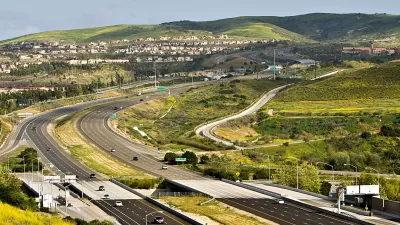
In the 1950s, southern Orange County, California was a place of open hills, citrus groves, and scattered towns. The I-5 Freeway changed that, paving the way for today's subdivisions.

Running parallel to the coast through the heart of the county, the I-5 Freeway follows the path of the El Camino Real, a famed route from California's Spanish period. "If Orange County had a skeleton, the 5 freeway would be its spine. [...] No other piece of infrastructure so thoroughly binds together the spatial structure of Orange County."
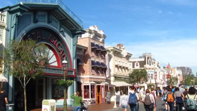
Nathan Masters gives us photos and advertisements from the 1950s, when the freeway was extended past a sparkling new Disneyland, opening up the "Southland." Unlike some L.A. County freeways, the 5 didn't displace residents. "[...] for much of its length, construction crews paved over orange groves, bean fields, and cattle pastures rather than residential neighborhoods; when construction began, Orange County was a decidedly rural place, an agricultural landscape dotted by a few small towns, distinct from the Los Angeles metropolis."
"Its backbone in place, Orange County soon evolved from its rural, embryonic form (1950 population: 216,224) into the fully realized postmodern metropolis (2010 population: 3,010,232) we know today." The 5, also known as the Santa Ana Freeway, now runs the length of the country from Mexico to Canada.
FULL STORY: How the 5 Freeway Made Orange County Suburban

What Will Disneyland Be Like When it Reopens?
According to a study, Disneyland could comfortably accommodate 50% of the 110-acre theme park’s pre-COVID-19 attendance capacity.
Plans Advance for Orange County Streetcar
The $289 million streetcar would serve the cities of Santa Ana (population 329,00), county seat and second densest in California after San Francisco, and Garden Grove (population 170,000) on a 4.1-mile route. Service could begin 2020.
A Pedestrian's Perspective on Sprawling Orange County
Southern California's Orange County isn't exactly known for its walkability. Frank H. Wu decided to test that notion on a recent carless visit.

Maui's Vacation Rental Debate Turns Ugly
Verbal attacks, misinformation campaigns and fistfights plague a high-stakes debate to convert thousands of vacation rentals into long-term housing.

Planetizen Federal Action Tracker
A weekly monitor of how Trump’s orders and actions are impacting planners and planning in America.

In Urban Planning, AI Prompting Could be the New Design Thinking
Creativity has long been key to great urban design. What if we see AI as our new creative partner?

King County Supportive Housing Program Offers Hope for Unhoused Residents
The county is taking a ‘Housing First’ approach that prioritizes getting people into housing, then offering wraparound supportive services.

Researchers Use AI to Get Clearer Picture of US Housing
Analysts are using artificial intelligence to supercharge their research by allowing them to comb through data faster. Though these AI tools can be error prone, they save time and housing researchers are optimistic about the future.

Making Shared Micromobility More Inclusive
Cities and shared mobility system operators can do more to include people with disabilities in planning and operations, per a new report.
Urban Design for Planners 1: Software Tools
This six-course series explores essential urban design concepts using open source software and equips planners with the tools they need to participate fully in the urban design process.
Planning for Universal Design
Learn the tools for implementing Universal Design in planning regulations.
planning NEXT
Appalachian Highlands Housing Partners
Mpact (founded as Rail~Volution)
City of Camden Redevelopment Agency
City of Astoria
City of Portland
City of Laramie