


After 34 years the Municipality of Anchorage is updating its land use plan map, a companion piece to its comprehensive plan adopted in 2001. The land use plan map sets the stage for future growth and development in this Northern City of 301,000.
APRN reporter Josh Edge writes, "The most-recent projections – which have been adjusted since the price of oil has declined – anticipate Anchorage’s population will grow between 15,000 and 45,000 people within the next 25 years. That means city planners need to figure out how Anchorage can change to accommodate the growth."
One third of the state's population and nearly half of its jobs puts Anchorage at the heart of an emerging metro region. The Land Use Plan Map update incorporates significant analysis of Anchorage's demographics and projected growth; current and future economic changes; current land sues; and future land capacity. This data informs the policies and strategies included in the LUPM update. Once adopted, the LUPM will provide guidance when developing other plans and making land use and development decisions, public infrastructure investments, and evaluating proposed zoning changes, in coordination with other elements of the Comprehensive Plan.
FULL STORY: Municipality updating Anchorage’s dated land use plan


Anchorage Leaders Support Multigenerational Housing Model
The city is making it easier to build multigenerational housing that can accommodate families, children, and seniors who want to ‘age in place.’
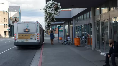
Anchorage Bus Depot to Reopen
After a four-year closure, a downtown Anchorage transit center will once again provide indoor waiting areas and services for bus travelers.

ForwardDallas Lays out Bold Vision, Lacks Teeth
The land use plan outlines ambitious goals for the city’s future, but offers little in the way of concrete changes.

Planetizen Federal Action Tracker
A weekly monitor of how Trump’s orders and actions are impacting planners and planning in America.

San Francisco's School District Spent $105M To Build Affordable Housing for Teachers — And That's Just the Beginning
SFUSD joins a growing list of school districts using their land holdings to address housing affordability challenges faced by their own employees.

The Tiny, Adorable $7,000 Car Turning Japan Onto EVs
The single seat Mibot charges from a regular plug as quickly as an iPad, and is about half the price of an average EV.

With Protected Lanes, 460% More People Commute by Bike
For those needing more ammo, more data proving what we already knew is here.

In More Metros Than You’d Think, Suburbs are Now More Expensive Than the City
If you're moving to the burbs to save on square footage, data shows you should think again.

The States Losing Rural Delivery Rooms at an Alarming Pace
In some states, as few as 9% of rural hospitals still deliver babies. As a result, rising pre-term births, no adequate pre-term care and "harrowing" close calls are a growing reality.
Urban Design for Planners 1: Software Tools
This six-course series explores essential urban design concepts using open source software and equips planners with the tools they need to participate fully in the urban design process.
Planning for Universal Design
Learn the tools for implementing Universal Design in planning regulations.
Smith Gee Studio
City of Charlotte
City of Camden Redevelopment Agency
City of Astoria
Transportation Research & Education Center (TREC) at Portland State University
US High Speed Rail Association
City of Camden Redevelopment Agency
Municipality of Princeton (NJ)