


A post on the Lexington Streetsweeper blog examines the idea of Farming Community Subdivision, or "agrihood," and the plausibility of such a community being created in Central Kentucky.
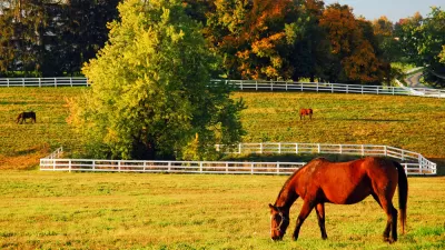
"In Central Kentucky, the historical trend has been to clear an agricultural property of all vestiges of its previous use, then name the development for what used to be there. To do otherwise goes against all rules of subdivision design and development. Agrihoods bend those rules into the symbiotic relationship of pioneer days," according to a post on The Lexington Streetsweeper blog to introduce the idea of Farming Community Subdivisions.
The post compares agrihoods to housing developments built next to a golf course, but "[instead] of golf, the amenity which draws these homeowners is the benefit of fresh food within walking distance. Their own CSA or farmers market in the backyard where they can participate or not."
The post related question about whether an agrihood would work in Central Kentucky to how badly Baby Boomers, Millennials, and parents desire these kind of amenities, especially because Farming Community Subdivisions are still, essentially, sprawl.
As noted by the article, the agrihood has recently gained renewed attention thanks to a 2,130-home development in Willowsford, Virginia covered by John Gittleson recently for Bloomberg Business, which "set aside 2,000 acres of green space, including 300 acres for raising fruit, vegetables, chickens, and goats." Beth Buczynski has also reported on the specifics of 12 agrihoods around the country.
FULL STORY: Can We Get A Farming Community Subdivision?


Water Concerns Follow New Development in Montana
Sprawling subdivision development in Montana is popping up in former agricultural land, pressuring water resources and leading to some legal controversy.
Support for Shrinking the Nation's Oldest Growth Boundary
Lexington, Kentucky's growth boundary survived a comprehensive plan update in 2019, after years of controversy. A housing crisis, a growing city, and a broken land use system are rearranging the political arithmetic behind the greenbelt.

Louisville's Sprawl Threatens One of its Last Clean-Running Streams
New subdivision planning and construction is expected to expand the footprint of the Louisville metropolitan area. The question is whether those new developments will protect or harm the beloved Floyds Fork.

Planetizen Federal Action Tracker
A weekly monitor of how Trump’s orders and actions are impacting planners and planning in America.

Map: Where Senate Republicans Want to Sell Your Public Lands
For public land advocates, the Senate Republicans’ proposal to sell millions of acres of public land in the West is “the biggest fight of their careers.”

Restaurant Patios Were a Pandemic Win — Why Were They so Hard to Keep?
Social distancing requirements and changes in travel patterns prompted cities to pilot new uses for street and sidewalk space. Then it got complicated.

Platform Pilsner: Vancouver Transit Agency Releases... a Beer?
TransLink will receive a portion of every sale of the four-pack.

Toronto Weighs Cheaper Transit, Parking Hikes for Major Events
Special event rates would take effect during large festivals, sports games and concerts to ‘discourage driving, manage congestion and free up space for transit.”

Berlin to Consider Car-Free Zone Larger Than Manhattan
The area bound by the 22-mile Ringbahn would still allow 12 uses of a private automobile per year per person, and several other exemptions.
Urban Design for Planners 1: Software Tools
This six-course series explores essential urban design concepts using open source software and equips planners with the tools they need to participate fully in the urban design process.
Planning for Universal Design
Learn the tools for implementing Universal Design in planning regulations.
Heyer Gruel & Associates PA
JM Goldson LLC
Custer County Colorado
City of Camden Redevelopment Agency
City of Astoria
Transportation Research & Education Center (TREC) at Portland State University
Camden Redevelopment Agency
City of Claremont
Municipality of Princeton (NJ)