


The Metropolitan Transportation Commission—the Bay Area's regional transportation planning agency—recently did fans of data and mapping a huge favor and launched a website called Vital Signs.
"Data lovers can now nerd out on a new website that collects Bay Area transportation data and puts it into customizable maps and charts that anyone can play with," reports Melanie Curry.
The website, called Vital Signs, is part of an open data project by the Metropolitan Transportation Commission (MTC), and could inform measurements if/when the beleaguered Plan Bay Area effort begins to shape the region.
"The first rollout of the website includes transportation data from a variety of sources, including the US Census. Land use data will be added in March. Information and measures of the economy–job creation, employment, and housing affordability–and environment—emissions, fuel sales, injuries from collisions–will complete the website by June," according to Curry's sources with the MTC.
Curry goes on to detail some of the uses of the portal, including comparisons between San Francisco and Los Angeles on measures of annual and daily transit ridership.
Members of the mainstream have already picked up on the tools available through Vital Signs, including Gary Richards for the Contra Costa Times and Ann Notarangelo for CBS SF Bay Area.
FULL STORY: New Data Website Tracks Bay Area Vital Signs

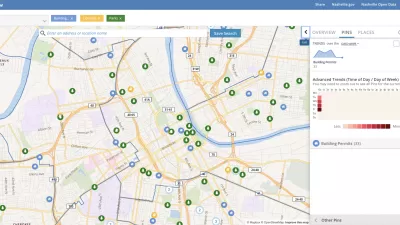
Presenting Municipal Data in an Interactive Map, Nashville Style
The city of Nashville launched the NashView interactive data map earlier this month.

DataUSA: An Intuitive Tool for Public Data
A collaboration between Deloitte, Datawheel, and MIT has produced an intuitive aesthetically-pleasing gathering point for public data in the United States. Specific locations and industries boast easy-to-read profiles.
Putting Alternative Fuel Stations on the Map
Yesterday, the U.S. Department of Energy released an interactive map displaying thousands of alternative fuel stations around the nation.

Planetizen Federal Action Tracker
A weekly monitor of how Trump’s orders and actions are impacting planners and planning in America.

Maui's Vacation Rental Debate Turns Ugly
Verbal attacks, misinformation campaigns and fistfights plague a high-stakes debate to convert thousands of vacation rentals into long-term housing.

San Francisco Suspends Traffic Calming Amidst Record Deaths
Citing “a challenging fiscal landscape,” the city will cease the program on the heels of 42 traffic deaths, including 24 pedestrians.

Defunct Pittsburgh Power Plant to Become Residential Tower
A decommissioned steam heat plant will be redeveloped into almost 100 affordable housing units.

Trump Prompts Restructuring of Transportation Research Board in “Unprecedented Overreach”
The TRB has eliminated more than half of its committees including those focused on climate, equity, and cities.

Amtrak Rolls Out New Orleans to Alabama “Mardi Gras” Train
The new service will operate morning and evening departures between Mobile and New Orleans.
Urban Design for Planners 1: Software Tools
This six-course series explores essential urban design concepts using open source software and equips planners with the tools they need to participate fully in the urban design process.
Planning for Universal Design
Learn the tools for implementing Universal Design in planning regulations.
Heyer Gruel & Associates PA
JM Goldson LLC
Custer County Colorado
City of Camden Redevelopment Agency
City of Astoria
Transportation Research & Education Center (TREC) at Portland State University
Jefferson Parish Government
Camden Redevelopment Agency
City of Claremont