


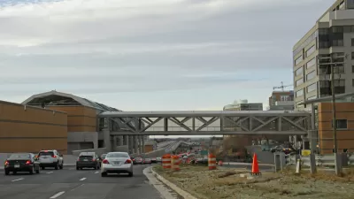
The Silver Line opened two and a half months ago. Already, with strong ridership in both directions, some businesses are seeing new opportunities.

But after two months of Silver Line service, questions remain: Will people move near these stations? Are nearby businesses seeing a boost to their bottom lines?
Commuter numbers for the five new stations suggest good things. On September 24, WMATA announced that after less than two months, 30,000 combined trips are being taken to or from Silver Line stations on weekdays. According to Metro, “the new line is already performing at 60 percent of its projected ridership for the end of the first full year of service.”
About a third of these trips are being made by new riders, the remainder, Metro estimates, are former Orange Line commuters who have switched to a closer station.

Population boom
Even before the Silver Line opened, new apartment buildings on the line have been filling up. The Ascent, a new high-rise luxury apartment close to the Spring Hill metro station, began accepting residents in April and is leasing at a pace that will have the 404-unit building filled in two years. The developer is so confident in Tysons' potential as a budding metropolis that it has broken ground on a second building, even closer to the Metro.
Greystar managing director Brandon Henry told the Washington Post he never thought the building would open before the Silver Line. He also didn’t anticipate such a rapid change in the area.
“I expected people to have rail come and then it would slowly build but people have really jumped in and gotten ahead," Henry told the Post.
These are just two of the dozen projects and 10,000 residential units targeted for the empty lots surrounding the new metro stations. Because of these, Tysons is expected to grow its population from 21,000 to over 100,000 by the year 2050.
FULL STORY: How the Silver Line may already be remaking Tysons

D.C. Metro's Silver Line Launches Passenger Service
After no small amount of debate, delay, and controversy, the first phase of D.C. Metro's Silver Line will launch passenger service today. The line will connect Washington D.C. to northwestern Virginia, including four stops in Tysons Corner.
D.C. Metro Considering Privatization of Operations and Maintenance on New Silver Line
A proposal to privatize operations and maintenance of stations and track on the Silver Line has taken an initial, tentative step forward.

Arlington County Reduces Parking Requirements for Multi-Family Developments on Metro Corridors
In addition to reducing parking requirements to 0.2 to 0.6 spaces per unit for developments "approved by special exception," the board went a step further by requiring mitigations if developers provide more than 1.65 spaces per unit.

Planetizen Federal Action Tracker
A weekly monitor of how Trump’s orders and actions are impacting planners and planning in America.

The Simple Legislative Tool Transforming Vacant Downtowns
In California, Michigan and Georgia, an easy win is bringing dollars — and delight — back to city centers.

San Francisco's School District Spent $105M To Build Affordable Housing for Teachers — And That's Just the Beginning
SFUSD joins a growing list of school districts using their land holdings to address housing affordability challenges faced by their own employees.

In More Metros Than You’d Think, Suburbs are Now More Expensive Than the City
If you're moving to the burbs to save on square footage, data shows you should think again.

The States Losing Rural Delivery Rooms at an Alarming Pace
In some states, as few as 9% of rural hospitals still deliver babies. As a result, rising pre-term births, no adequate pre-term care and "harrowing" close calls are a growing reality.

The Small South Asian Republic Going all in on EVs
Thanks to one simple policy change less than five years ago, 65% of new cars in this Himalayan country are now electric.
Urban Design for Planners 1: Software Tools
This six-course series explores essential urban design concepts using open source software and equips planners with the tools they need to participate fully in the urban design process.
Planning for Universal Design
Learn the tools for implementing Universal Design in planning regulations.
Smith Gee Studio
City of Charlotte
City of Camden Redevelopment Agency
City of Astoria
Transportation Research & Education Center (TREC) at Portland State University
US High Speed Rail Association
City of Camden Redevelopment Agency
Municipality of Princeton (NJ)