


City Clock prepared two lists of neighborhoods with the most commute trips made without cars (for every city BUT New York City). One list ranks university neighborhoods, and the other non-university neighborhoods.
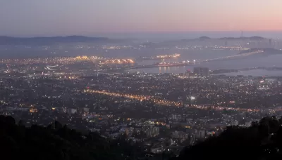
City Clock prepared the rankings of neighborhood car with 2010 census data at the tract level for car mode share, claiming "[while] it only considers work trips, this is usually a good indication of overall walking in a neighborhood."
City Clock also made choices to remove New York City from the rankings and to make two lists instead of one, that latter decision was made "to separate neighborhoods that are highly influenced by university activities and those that aren’t."
Tops on the university neighborhood list: Berkeley, California. Tops on the non-university list: the Tenderloin in San Francisco.
FULL STORY: Top 10 Most Car Independent Neighborhoods in America by the numbers (outside NYC)

Car-Free Cities, Measured
The CityLab team has created a new metric to measure the U.S. cities where people are most likely to be car free.
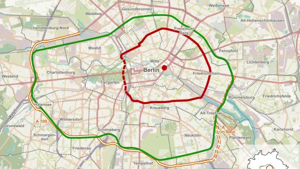
Berlin to Consider Car-Free Zone Larger Than Manhattan
The area bound by the 22-mile Ringbahn would still allow 12 uses of a private automobile per year per person, and several other exemptions.

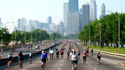
Growing up Car-Free in Chicago
One Chicago youth recounts their experience growing up in a car-free household.

Planetizen Federal Action Tracker
A weekly monitor of how Trump’s orders and actions are impacting planners and planning in America.

Map: Where Senate Republicans Want to Sell Your Public Lands
For public land advocates, the Senate Republicans’ proposal to sell millions of acres of public land in the West is “the biggest fight of their careers.”

Restaurant Patios Were a Pandemic Win — Why Were They so Hard to Keep?
Social distancing requirements and changes in travel patterns prompted cities to pilot new uses for street and sidewalk space. Then it got complicated.

Platform Pilsner: Vancouver Transit Agency Releases... a Beer?
TransLink will receive a portion of every sale of the four-pack.

Toronto Weighs Cheaper Transit, Parking Hikes for Major Events
Special event rates would take effect during large festivals, sports games and concerts to ‘discourage driving, manage congestion and free up space for transit.”

Berlin to Consider Car-Free Zone Larger Than Manhattan
The area bound by the 22-mile Ringbahn would still allow 12 uses of a private automobile per year per person, and several other exemptions.
Urban Design for Planners 1: Software Tools
This six-course series explores essential urban design concepts using open source software and equips planners with the tools they need to participate fully in the urban design process.
Planning for Universal Design
Learn the tools for implementing Universal Design in planning regulations.
Heyer Gruel & Associates PA
JM Goldson LLC
Custer County Colorado
City of Camden Redevelopment Agency
City of Astoria
Transportation Research & Education Center (TREC) at Portland State University
Camden Redevelopment Agency
City of Claremont
Municipality of Princeton (NJ)