


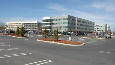
To address the growth of commute traffic to the Google campus and neighboring tech companies in the north (of Hwy. 101) part of this city of 74,000 in Silicon Valley, the city council is proposing a toll on all three road entrances to the area.
Google just can't get a break. Either their commute buses are attacked (literally, in some cases) in San Francisco, or the commute traffic to their Silicon Valley campus is targeted, and may be used as a reason to reduce building expansion.
The Mountain View city council may very well beat both Manhattan and San Francisco in applying congestion (or cordon) pricing as a way to reduce auto traffic. Daniel DeBolt of the local Mountain View Voice writes that "on Monday (April 28), City Council members supported the use of "congestion pricing" as a means to enforce proposed limits on commuter traffic into the city's growing North Bayshore office park."
Like the system now used to collect tolls on the Golden Gate Bridge, license plate cameras are proposed for the three "gateway" roads providing the only vehicle access to the north side of Highway 101 in Mountain View, potentially enforcing a yet-to-be-determined fee on thousands of employees of Google, Intuit, Microsoft and others who choose to commute by car during morning rush hour instead of taking a shuttle or a bike.
Unlike the Manhattan and San Francisco plans, the plan appears mainly to measure commute traffic as opposed to raising revenue from the cordon toll. Presumably the toll would be used primarily to create the disincentive to drive to work during peak hours.
If approved in December as part of a "North Bayshore precise plan," Google and others would not be allowed to build up to 3.4 million square feet of new offices in North Bayshore unless traffic on the three roads is kept under their collective capacity limit of 18,900 trips between 7 a.m. and 10 a.m. -- the "cap".
Google does not appear to be on board with the plan - preferring to build their way out of congestion. Google transportation planner Jeral Poskey "suggested the city try other measures first to manage traffic, including a new Charleston Road underpass to connect the road across Highway 101, and a new Highway 101 off-ramp onto Huff Avenue, possibly allowing better Google bus access."
Let's do everything we can to improve (streets and intersections), then we can give up and say, that's the trip cap," said Poskey, who is overseeing the development of transportation strategy for Google in Mountain View.
The idea for the commute cap comes from neighboring Palo Alto who have successfully tamed car traffic to the Stanford University campus by using a county-imposed car trip "cap". Mountain View liked the idea of applying a market strategy to reach their trip reduction goal.
"Mayor Chris Clark described congestion pricing as a really good final tool we would have in our tool belt' to enforce such a cap," writes deBolt.
Not mentioned is whether state legislation would be required to apply a toll to city streets - although the toll would technically be applied to the 'gateway'. San Francisco, 36 miles to the north, would have sought legislation to implement their plan as the San Francisco Chronicle noted in 2008. Sadly, the plan doesn't appear to have moved past the study phase.
FULL STORY: "Congestion pricing" part of plan for Google's growth

Tech Giants Bank on Growth, Acquire More Space
To provide room for long-term expansion, companies like Google, Facebook, and LinkedIn are buying up even more Bay Area real estate. Their flush cash reserves have them nudging out the traditional development and investment crowd.
Hetch Hetchy Valley Haunts, and Nourishes, San Francisco
Voters in S.F. will be given an opportunity to right a perceived 100 year old environmental wrong next week when they cast ballots on whether to develop a multi-billion dollar plan to drain Hetch Hetchy Valley, the city’s pristine water source.

Google Seeks New Direction for Massive Housing Proposal
The company parted ways with its development partner, signaling a shift in strategy for a proposed 15,000-unit housing and office space project on Google-owned land in Silicon Valley.

Maui's Vacation Rental Debate Turns Ugly
Verbal attacks, misinformation campaigns and fistfights plague a high-stakes debate to convert thousands of vacation rentals into long-term housing.

Planetizen Federal Action Tracker
A weekly monitor of how Trump’s orders and actions are impacting planners and planning in America.

San Francisco Suspends Traffic Calming Amidst Record Deaths
Citing “a challenging fiscal landscape,” the city will cease the program on the heels of 42 traffic deaths, including 24 pedestrians.

Half of Post-Fire Altadena Home Sales Were to Corporations
Large investors are quietly buying up dozens of properties in Altadena, California, where a devastating wildfire destroyed more than 6,000 homes in January.

Opinion: What San Francisco’s Proposed ‘Family Zoning’ Could Really Mean
Mayor Lurie is using ‘family zoning’ to encourage denser development and upzoning — but could the concept actually foster community and more human-scale public spaces?

Jacksonville Launches First Autonomous Transit Shuttle in US
A fleet of 14 fully autonomous vehicles will serve a 3.5-mile downtown Jacksonville route with 12 stops.
Urban Design for Planners 1: Software Tools
This six-course series explores essential urban design concepts using open source software and equips planners with the tools they need to participate fully in the urban design process.
Planning for Universal Design
Learn the tools for implementing Universal Design in planning regulations.
Gallatin County Department of Planning & Community Development
Heyer Gruel & Associates PA
JM Goldson LLC
City of Camden Redevelopment Agency
City of Astoria
Transportation Research & Education Center (TREC) at Portland State University
Jefferson Parish Government
Camden Redevelopment Agency
City of Claremont