


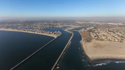
Efforts to transform L.A.'s maligned river into a public and economic asset got a boost last week with the establishment of a cross-disciplinary and cross-agency planning effort focused on an eight-mile stretch of the river.
Funded by a $2.25 million Community Challenge planning grant from the Federal Partnership for Sustainable Communities, the Northeast Los Angeles Riverfront Collaborative (NELA RC) was officially launched last week as, "a holistic, collaborative urban planning effort to take advantage of the River as an economic development asset," reports Carren Jao. "The collaborative takes up the mantle left behind when the state's Community Redevelopment Agencies were dissolved last year, but with added emphasis on inter-agency cooperation and community-based approaches."
"The idea here is to use the [Los Angeles] river -- which has historically been a flood control basin -- and envision it as an actual fully-functioning river and to use that to create a district where it'll be a unique feature," said Louis Morales of Tierra West, project manager of NELA RC.
"NELA RC is an ambitious effort that attempts to break down the barriers that often exist in agencies, said George Villanueva, researcher for the Metamorphosis Project at the University of Southern California's Annenberg School for Communication.'It's not just government agencies, but non-profits, universities, commercial real estate people. It's really ambitious to get all of these people working together.'"
"Should it prove successful," adds Jao, "it could become a template for future urban planning and management."
FULL STORY: Northeast L.A. Communities to be Envisioned as a Riverfront District


Annual LA River CleanUp Invites Residents to Protect Local Ecosystems
The Friends of the Los Angeles River will host its 34th Annual LA River CleanUp on October 5, inviting residents to help beautify the river, prevent litter from reaching the ocean, and promote equitable access to green spaces.

Revitalizing Sepulveda Basin: A Green Vision for An Urban Oasis
Developed through the input of thousands of community members, this is the first comprehensive plan by the City of Los Angeles for the 2,000-acre basin.
L.A. County Calls for Flood Control Improvements
Recently revealed estimates put far more people in the region at risk for catastrophic flooding than previously thought.

Planetizen Federal Action Tracker
A weekly monitor of how Trump’s orders and actions are impacting planners and planning in America.

Map: Where Senate Republicans Want to Sell Your Public Lands
For public land advocates, the Senate Republicans’ proposal to sell millions of acres of public land in the West is “the biggest fight of their careers.”

Restaurant Patios Were a Pandemic Win — Why Were They so Hard to Keep?
Social distancing requirements and changes in travel patterns prompted cities to pilot new uses for street and sidewalk space. Then it got complicated.

Platform Pilsner: Vancouver Transit Agency Releases... a Beer?
TransLink will receive a portion of every sale of the four-pack.

Toronto Weighs Cheaper Transit, Parking Hikes for Major Events
Special event rates would take effect during large festivals, sports games and concerts to ‘discourage driving, manage congestion and free up space for transit.”

Berlin to Consider Car-Free Zone Larger Than Manhattan
The area bound by the 22-mile Ringbahn would still allow 12 uses of a private automobile per year per person, and several other exemptions.
Urban Design for Planners 1: Software Tools
This six-course series explores essential urban design concepts using open source software and equips planners with the tools they need to participate fully in the urban design process.
Planning for Universal Design
Learn the tools for implementing Universal Design in planning regulations.
Heyer Gruel & Associates PA
JM Goldson LLC
Custer County Colorado
City of Camden Redevelopment Agency
City of Astoria
Transportation Research & Education Center (TREC) at Portland State University
Camden Redevelopment Agency
City of Claremont
Municipality of Princeton (NJ)