


The Bay Area's transportation agency, the Metropolitan Transportation Commission, approved a comprehensive plan for regional High Occupancy Toll lanes, mostly from conversions of existing and already-planned carpool lanes, totaling almost 800 miles.
"The region-wide project along segments of 12 highways would cost an estimated $3.7 billion to build. Officials anticipate the system will generate more than $6 billion in 25 years - enough money to cover the project's expenses and produce additional cash for other roadway and transit improvements."
"The toll roads would be incorporated into existing carpool lanes, which now comprise about 350 miles of freeway, and the approximately 140 miles of additional carpool lanes now under construction. The plan calls for building another 300 or so miles of the lanes to fill in the gaps and create a seamless network."
"Officials anticipate that solo drivers initially would pay 20 to 60 cents per mile in the early years of the program, and perhaps up to $1 per mile in 2030. Carpools, vanpools, mass transit and motorcyclists would continue to use the priority lanes for free.
Under the scheme, people driving alone would enter and exit the express lanes at designated locations and be tracked via a network of electronic readers erected along the freeways that link to a FasTrak transponder in the vehicles."
Thanks to ABAG-MTC Library
FULL STORY: Bay Area officials approve toll-lane network

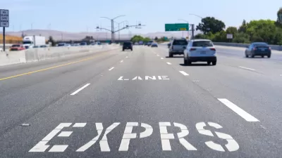
Congestion Pricing in the San Francisco Bay Area
Planners call them “express lanes,” but make no mistake, they are congestion pricing in action, and they're successful. The Bay Area network of what the Federal Highway Administration calls “high-occupancy toll (HOT) lanes” is growing.

Tollways for Sacramento?
Road pricing terminology can be confusing, particularly since Californians see so little of it. For example, a Sacramento TV station calls proposed express lanes on Interstate 80 from Solano County to Sacramento a ‘tollway.’
The ‘Three Pillars’ of Carbon Reduction, According to Caltrans
The California Department of Transportation released its draft carbon reduction strategy last month to apply for Carbon Reduction Program funds included in the Infrastructure Investment and Jobs Act. Road pricing plays a prominent role.

Planetizen Federal Action Tracker
A weekly monitor of how Trump’s orders and actions are impacting planners and planning in America.

Restaurant Patios Were a Pandemic Win — Why Were They so Hard to Keep?
Social distancing requirements and changes in travel patterns prompted cities to pilot new uses for street and sidewalk space. Then it got complicated.

Map: Where Senate Republicans Want to Sell Your Public Lands
For public land advocates, the Senate Republicans’ proposal to sell millions of acres of public land in the West is “the biggest fight of their careers.”

Maui's Vacation Rental Debate Turns Ugly
Verbal attacks, misinformation campaigns and fistfights plague a high-stakes debate to convert thousands of vacation rentals into long-term housing.

San Francisco Suspends Traffic Calming Amidst Record Deaths
Citing “a challenging fiscal landscape,” the city will cease the program on the heels of 42 traffic deaths, including 24 pedestrians.

California Homeless Arrests, Citations Spike After Ruling
An investigation reveals that anti-homeless actions increased up to 500% after Grants Pass v. Johnson — even in cities claiming no policy change.
Urban Design for Planners 1: Software Tools
This six-course series explores essential urban design concepts using open source software and equips planners with the tools they need to participate fully in the urban design process.
Planning for Universal Design
Learn the tools for implementing Universal Design in planning regulations.
Heyer Gruel & Associates PA
JM Goldson LLC
Custer County Colorado
City of Camden Redevelopment Agency
City of Astoria
Transportation Research & Education Center (TREC) at Portland State University
Camden Redevelopment Agency
City of Claremont
Municipality of Princeton (NJ)