


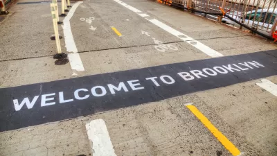
A new web site that generates directions for cyclists could supplant the New York City Bike Map.
"On Sunday, three enterprising cyclists launched 'Ride the City,' a web site that finds the safest and most efficient routes for those on two wheels. Here's how it works:"
"'The concept is pretty simple. Just like MapQuest, Google, Microsoft, and other mapping programs, Ride the City finds the shortest distance between two points. But there are two major differences. First, RTC excludes roads that aren't meant for biking, like the BQE and the Queens Midtown tunnel. Second, RTC tries to locate routes that maximize the use of bike lanes and greenways.'"
"Once your route is determined, the mapping software provides directions and displays bike shops along the way. Though perfectly functional, Ride the City is still in the testing phase. Its creators are looking for feedback to help improve route selection, and plan to add functionality, like locating bike parking facilities, in the future."
Thanks to Ben Fried
FULL STORY: NYC Bicyclists Get Their Own MapQuest

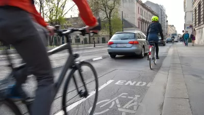
Brooklyn Bridge Bike Path Could Be Wider, Safer
Advocates want to see a safer plan for the proposed two-way path on one of the country's busiest commuter corridors.
Large Cities Were Already Losing Population. Then Came the Coronavirus.
"Cities of all sizes may soon look less alluring, if drastic drops in income, sales and tourism tax revenue leave gaping holes in budgets," according to this article, which encapsulates a popular school of thought as the pandemic rages.
Vision Zero Is Not Improving Bike Safety
The initiative focuses on safety, but fatalities are up and ridership growth is down in New York City. How is Vision Zero missing the mark?

Planetizen Federal Action Tracker
A weekly monitor of how Trump’s orders and actions are impacting planners and planning in America.

Map: Where Senate Republicans Want to Sell Your Public Lands
For public land advocates, the Senate Republicans’ proposal to sell millions of acres of public land in the West is “the biggest fight of their careers.”

Restaurant Patios Were a Pandemic Win — Why Were They so Hard to Keep?
Social distancing requirements and changes in travel patterns prompted cities to pilot new uses for street and sidewalk space. Then it got complicated.

Platform Pilsner: Vancouver Transit Agency Releases... a Beer?
TransLink will receive a portion of every sale of the four-pack.

Toronto Weighs Cheaper Transit, Parking Hikes for Major Events
Special event rates would take effect during large festivals, sports games and concerts to ‘discourage driving, manage congestion and free up space for transit.”

Berlin to Consider Car-Free Zone Larger Than Manhattan
The area bound by the 22-mile Ringbahn would still allow 12 uses of a private automobile per year per person, and several other exemptions.
Urban Design for Planners 1: Software Tools
This six-course series explores essential urban design concepts using open source software and equips planners with the tools they need to participate fully in the urban design process.
Planning for Universal Design
Learn the tools for implementing Universal Design in planning regulations.
Heyer Gruel & Associates PA
JM Goldson LLC
Custer County Colorado
City of Camden Redevelopment Agency
City of Astoria
Transportation Research & Education Center (TREC) at Portland State University
Camden Redevelopment Agency
City of Claremont
Municipality of Princeton (NJ)