


A team of researchers is developing a dataset to fill a critical gap in self-driving cars’ learning models.

Researchers at the University of Maryland are working to make autonomous vehicles safer for blind pedestrians, reports Laurie Robinson in Maryland Today. According to the researchers, autonomous cars lack “solid data” for how blind pedestrians move and navigate streets and sidewalks.
“The oversight can hinder the ability of autonomous vehicles to safely predict the movements of blind pedestrians, whose behaviors, such as using a cane to feel the curbs or veering, might confuse current models, leading to potentially dangerous errors.” The research team is creating a dataset called BlindWays that uses real-world 3D motion-capture data to help the systems understand blind pedestrians more effectively.
In testing, the model reduced prediction errors by over 80 percent in some cases. “To enhance and expand the BlindWays dataset, the researchers plan to collaborate with organizations specializing in disability rights, mobility training and urban planning. These partnerships aim to diversify participants, locations and scenarios in the dataset.”
FULL STORY: Autonomous Cars Don’t Understand How Blind People Move Around. A Research Team Is Trying to Boost Safety.

NHTSA Cuts Could Make Roads More Dangerous
The agency is losing almost half of the team that oversees autonomous vehicle safety, among dozens of other key personnel.

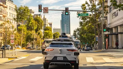
Federal Regulators Ask Tesla for Robotaxi Details Ahead of Planned Launch
Tesla CEO Elon Musk says the company will launch self-driving taxis in Austin in June and other U.S. cities by the end of the year.

USDOT Waters Down Self-Driving Car Regulations
The agency is reducing reporting requirements for autonomous vehicles and cars with self-driving features, prompting concern among safety advocates who say transparency is essential to the safe deployment of AV technology.

Planetizen Federal Action Tracker
A weekly monitor of how Trump’s orders and actions are impacting planners and planning in America.

Maui's Vacation Rental Debate Turns Ugly
Verbal attacks, misinformation campaigns and fistfights plague a high-stakes debate to convert thousands of vacation rentals into long-term housing.

Restaurant Patios Were a Pandemic Win — Why Were They so Hard to Keep?
Social distancing requirements and changes in travel patterns prompted cities to pilot new uses for street and sidewalk space. Then it got complicated.

In California Battle of Housing vs. Environment, Housing Just Won
A new state law significantly limits the power of CEQA, an environmental review law that served as a powerful tool for blocking new development.

Boulder Eliminates Parking Minimums Citywide
Officials estimate the cost of building a single underground parking space at up to $100,000.

Orange County, Florida Adopts Largest US “Sprawl Repair” Code
The ‘Orange Code’ seeks to rectify decades of sprawl-inducing, car-oriented development.
Urban Design for Planners 1: Software Tools
This six-course series explores essential urban design concepts using open source software and equips planners with the tools they need to participate fully in the urban design process.
Planning for Universal Design
Learn the tools for implementing Universal Design in planning regulations.
Heyer Gruel & Associates PA
JM Goldson LLC
Custer County Colorado
City of Camden Redevelopment Agency
City of Astoria
Transportation Research & Education Center (TREC) at Portland State University
Jefferson Parish Government
Camden Redevelopment Agency
City of Claremont