


The draft plan targets improvements on 385 road segments.
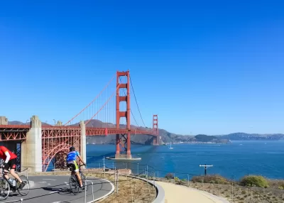
The San Francisco Municipal Transportation Agency (SFMTA) board is set to review the city’s draft Biking and Rolling plan, which sets the goal of putting a “safe bike route” within a quarter mile of every resident’s home.
As Rachel Swan explains in the San Francisco Chronicle, “The current draft lists 385 routes or street segments that are targeted for upgrades, ranging from brighter striping on crosswalks, to barriers along bike lanes.” The city wants to encourage residents to use bikes for short, local trips by making neighborhood roads safer for kids and older riders, particularly near schools.
The plan calls for more interconnected bikeways, speed bumps, and other measures to improve safety and link existing bike lanes, as well as reducing conflicts between pedestrians and scooters. But it could face backlash from residents concerned about the loss of parking and driving lanes.
Swan adds, “Roads are a utility. But they also reflect a city’s values. For decades, San Franciscans have battled over how streets should function and which transportation modes should get priority. In recent years, SFMTA has reclaimed space from cars and dedicated it for bikes, scooters, or pedestrians, instituting a ‘quick-build’ process to streamline these projects.”
FULL STORY: S.F. to unveil its most ambitious bicycle plan in years, targeting hundreds of routes for upgrades

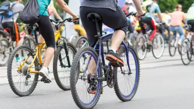
St. Petersburg’s Bike Infrastructure Efforts Pay Off
New bike infrastructure is encouraging more people to take to the streets on two wheels, but advocates say safety challenges remain.
Bike Resolutions for the New Year
A list of ways people can enhance their biking experience, appreciate the joy of cycling, and support safer bike infrastructure.

The Rippling Effects of Bike-to-Work Subsidies
A European movement to incentivize people to commute by bicycle is changing travel patterns and making mobility more sustainable.

Planetizen Federal Action Tracker
A weekly monitor of how Trump’s orders and actions are impacting planners and planning in America.

Congressman Proposes Bill to Rename DC Metro “Trump Train”
The Make Autorail Great Again Act would withhold federal funding to the system until the Washington Metropolitan Area Transit Authority (WMATA), rebrands as the Washington Metropolitan Authority for Greater Access (WMAGA).

DARTSpace Platform Streamlines Dallas TOD Application Process
The Dallas transit agency hopes a shorter permitting timeline will boost transit-oriented development around rail stations.

Renters Now Outnumber Homeowners in Over 200 US Suburbs
High housing costs in city centers and the new-found flexibility offered by remote work are pushing more renters to suburban areas.

The Tiny, Adorable $7,000 Car Turning Japan Onto EVs
The single seat Mibot charges from a regular plug as quickly as an iPad, and is about half the price of an average EV.

Supreme Court Ruling in Pipeline Case Guts Federal Environmental Law
The decision limits the scope of a federal law that mandates extensive environmental impact reviews of energy, infrastructure, and transportation projects.
Urban Design for Planners 1: Software Tools
This six-course series explores essential urban design concepts using open source software and equips planners with the tools they need to participate fully in the urban design process.
Planning for Universal Design
Learn the tools for implementing Universal Design in planning regulations.
Roanoke Valley-Alleghany Regional Commission
City of Mt Shasta
City of Camden Redevelopment Agency
City of Astoria
Transportation Research & Education Center (TREC) at Portland State University
US High Speed Rail Association
City of Camden Redevelopment Agency
Municipality of Princeton (NJ)