


Austin's Visio Zero program is hard at work, making significant changes to some of the city's most dangerous intersections.
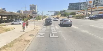
The Austin Transportation Department has begun work on safety improvements at some of the city’s dangerous intersections—located in Downtown Austin between Interstate 35 frontage roads and Seventh and Eighth streets.
Sarah Asch reports on the safety projects for the Austin American-Statesman, noting that the intersections were identified for upgrades by the city’s Vision Zero plan, and are funded by the city’s 2016 mobility bond [pdf].
“The projects include curb and ramp improvements to make the area safer for pedestrians on Seventh Street on both sides of the highway. The intersection between Seventh Street and the southbound I-35 frontage road will also have a new section of bike lane installed,” reports Asch.
“In the intersection between Seventh Street and the northbound frontage road, the city plans to install a high-visibility crosswalk, which uses an unusual pattern to be more visible to pedestrians and drivers, and a raised median island to improve pedestrian safety. Another high-visibility crosswalk will be installed one block up at the intersection between Eighth Street and the northbound frontage road.”
More details on the projects and Austin’s Vision Zero program are included in the source article below.
FULL STORY: City remaking high-crash intersections on some downtown Austin streets

How Understanding Near-Misses Can Improve Road Safety
Most road safety efforts are based on data about crashes that have already occurred. But important information can be gleaned from incidents when something almost went wrong, but didn’t.

Austin Left Turn Improvements Cut Serious Crashes by Half
Changes to left turn infrastructure and signal timing led to a 47 to 72 percent drop in fatal and serious injury crashes.
Report: Vision Zero Saving Lives in Austin
Safety improvements at major intersections led to a 22 percent reduction in deaths and severe injuries and saved the city over $28 million.

Maui's Vacation Rental Debate Turns Ugly
Verbal attacks, misinformation campaigns and fistfights plague a high-stakes debate to convert thousands of vacation rentals into long-term housing.

Planetizen Federal Action Tracker
A weekly monitor of how Trump’s orders and actions are impacting planners and planning in America.

In Urban Planning, AI Prompting Could be the New Design Thinking
Creativity has long been key to great urban design. What if we see AI as our new creative partner?

Massachusetts Budget Helps Close MBTA Budget Gap
The budget signed by Gov. Maura Healey includes $470 million in MBTA funding for the next fiscal year.

Milwaukee Launches Vision Zero Plan
Seven years after the city signed its Complete Streets Policy, the city is doubling down on its efforts to eliminate traffic deaths.

Portland Raises Parking Fees to Pay for Street Maintenance
The city is struggling to bridge a massive budget gap at the Bureau of Transportation, which largely depleted its reserves during the Civd-19 pandemic.
Urban Design for Planners 1: Software Tools
This six-course series explores essential urban design concepts using open source software and equips planners with the tools they need to participate fully in the urban design process.
Planning for Universal Design
Learn the tools for implementing Universal Design in planning regulations.
Gallatin County Department of Planning & Community Development
Heyer Gruel & Associates PA
JM Goldson LLC
City of Camden Redevelopment Agency
City of Astoria
Transportation Research & Education Center (TREC) at Portland State University
Jefferson Parish Government
Camden Redevelopment Agency
City of Claremont