


After a 19-year hiatus, the city is restarting its traffic calming program to combat the growing pedestrian death crisis.
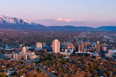
Almost two decades after Salt Lake City’s last traffic calming projects, a rise in pedestrian deaths has prompted the city to revive its traffic calming program. Jordan Miller details the city’s plan in an article for the Salt Lake Tribune.
A 2019 study assessed the city’s most dangerous roads and potential solutions for improving traffic safety. “The study’s final report identified 403.5 miles of roadway within Salt Lake City for possible improvements and divided those streets into 113 prioritized zones — based on crash data, speed data, demographics and community assets like schools.”
Program components include three versions of speed bumps, raised crosswalks to improve pedestrian visibility, pedestrian refuge islands, and roundabouts. Many of these treatments function best when combined: pedestrian refuge islands and raised crosswalks, for example, provide the most added safety when combined with other speed deflection measures.
See the source article for projected costs and more details on each type of project, the extent of which will depend on future funding.
FULL STORY: In Salt Lake City, here’s what kind of ‘traffic-calming’ projects could be coming to your street


Banning Right Turns on Red Just One Step Toward Vision Zero
Experts caution that blanket bans on right turns on red make only a slight contribution to reducing fatal crashes, and other interventions are needed to bring down traffic fatalities.
Vision Zero at Work: Hoboken Celebrates Seven Years of Zero Traffic Deaths
The New Jersey city implemented simple yet impactful changes to eliminate traffic fatalities.

Washington Focuses Road Safety Efforts on Individuals, Neglecting Design
Legislative efforts to reduce traffic deaths could move the needle toward Vision Zero, but state leaders failed to commit infrastructure funds to making structural improvements.

Planetizen Federal Action Tracker
A weekly monitor of how Trump’s orders and actions are impacting planners and planning in America.

San Francisco's School District Spent $105M To Build Affordable Housing for Teachers — And That's Just the Beginning
SFUSD joins a growing list of school districts using their land holdings to address housing affordability challenges faced by their own employees.

The Tiny, Adorable $7,000 Car Turning Japan Onto EVs
The single seat Mibot charges from a regular plug as quickly as an iPad, and is about half the price of an average EV.

As Trump Phases Out FEMA, Is It Time to Flee the Floodplains?
With less federal funding available for disaster relief efforts, the need to relocate at-risk communities is more urgent than ever.

With Protected Lanes, 460% More People Commute by Bike
For those needing more ammo, more data proving what we already knew is here.

In More Metros Than You’d Think, Suburbs are Now More Expensive Than the City
If you're moving to the burbs to save on square footage, data shows you should think again.
Urban Design for Planners 1: Software Tools
This six-course series explores essential urban design concepts using open source software and equips planners with the tools they need to participate fully in the urban design process.
Planning for Universal Design
Learn the tools for implementing Universal Design in planning regulations.
Smith Gee Studio
City of Charlotte
City of Camden Redevelopment Agency
City of Astoria
Transportation Research & Education Center (TREC) at Portland State University
US High Speed Rail Association
City of Camden Redevelopment Agency
Municipality of Princeton (NJ)