


A controversial road diet has faced disapproval from local business owners, but data shows a significant reduction in crashes and a minimal increase in congestion.
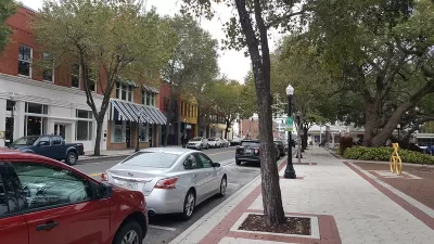
After implementing a controversial road diet, the city of Lakeland, Florida has seen a 12% drop in crashes in the area, reports Staci DaSilva for WFLA. Last September, the city reduced one mile of South Florida Avenue to three lanes (down from four) and widened the remaining lanes to the industry-standard 11 feet, placing temporary concrete buffers between the sidewalk and traffic lanes.
Some local business owners have expressed disapproval for the redesigned street, claiming that they are losing customers frustrated by increased congestion and expressing concern about access for emergency vehicles. City officials say that, according to the data, the road diet has only added an average of 60 seconds to the time it takes to traverse the affected stretch of road, and the number of vehicles passing through the area on a daily basis hasn't changed. Other locals support the project, arguing that "the new setup is not only safer, but actually good for business." In a phenomenon dubbed "good congestion," a mild slowdown "allows drivers to pay attention to local storefronts."
The city will accept public suggestions for how to utilize the buffer space and make the changes permanent.
FULL STORY: Lakeland ‘road diet’ leads to fewer crashes, more congestion, city officials say


USDOT Waters Down Self-Driving Car Regulations
The agency is reducing reporting requirements for autonomous vehicles and cars with self-driving features, prompting concern among safety advocates who say transparency is essential to the safe deployment of AV technology.
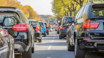
Study: Larger Vehicles Lead to More Congestion
New research links large SUVs to lower traffic throughput.

How I Learned to Stop Worrying and Love the Roundabout
What drives the U.S. backlash to roundabouts — objectively safer and more efficient than stop-and-go intersections?

Maui's Vacation Rental Debate Turns Ugly
Verbal attacks, misinformation campaigns and fistfights plague a high-stakes debate to convert thousands of vacation rentals into long-term housing.

Planetizen Federal Action Tracker
A weekly monitor of how Trump’s orders and actions are impacting planners and planning in America.

San Francisco Suspends Traffic Calming Amidst Record Deaths
Citing “a challenging fiscal landscape,” the city will cease the program on the heels of 42 traffic deaths, including 24 pedestrians.

Adaptive Reuse Will Create Housing in a Suburban Texas Strip Mall
A developer is reimagining a strip mall property as a mixed-use complex with housing and retail.

Study: Anti-Homelessness Laws Don’t Work
Research shows that punitive measures that criminalized unhoused people don’t help reduce homelessness.

In U.S., Urban Gondolas Face Uphill Battle
Cities in Latin America and Europe have embraced aerial transitways — AKA gondolas — as sustainable, convenient urban transport, especially in tricky geographies. American cities have yet to catch up.
Urban Design for Planners 1: Software Tools
This six-course series explores essential urban design concepts using open source software and equips planners with the tools they need to participate fully in the urban design process.
Planning for Universal Design
Learn the tools for implementing Universal Design in planning regulations.
Heyer Gruel & Associates PA
JM Goldson LLC
Custer County Colorado
City of Camden Redevelopment Agency
City of Astoria
Transportation Research & Education Center (TREC) at Portland State University
Jefferson Parish Government
Camden Redevelopment Agency
City of Claremont