


The temporary measures of the coronavirus pandemic are being made permanent fixtures on 20 miles of streets in Seattle.
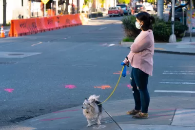
Michelle Baruchman reports: "Nearly 20 miles of Seattle streets will permanently close to most vehicle traffic by the end of May, Mayor Jenny Durkan announced Thursday."
The streets had been closed to most vehicle traffic after Governor jay Inslee implemented a statewide stay-at-home order in March, but the mayor is deciding the changes should stay in place after the order is lifted, making it the first U.S. city to make permanent street design changes implemented under the emergency conditions of the pandemic.
"The program, which has rolled out in phases, has been implemented in the Aurora-Licton Springs, Ballard, Central District, West Seattle, Greenwood, Othello, Rainier Beach and Beacon Hill neighborhoods," according to Baruchman.
Seattle Department of Transportation Director Sam Zimbabwe is quoted in the article introducing the possibility that additional changes to traffic flows could be implemented as the social distancing requirements of the pandemic linger.
FULL STORY: Seattle will permanently close 20 miles of residential streets to most vehicle traffic

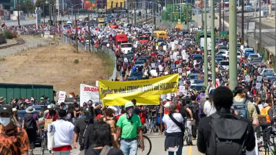
How Oakland Is Fixing its Pandemic Planning Equity Problem
The Oakland Slow Streets program, one of the most controversial developments of the early pandemic, has evolved to become the Essential Places initiative, thanks to new planning practices and a commitment to equity in Oakland, California.

NACTO Releases Pandemic Streets Design Guide
After three months of study and analysis, NACTO is providing authoritative guidance on new ways of thinking about rights of way now that the coronavirus has changed the way we live and work in cities.
Watch Oakland's Slow Streets Program in Action
Oakland offers a model for other streets looking to provide new space for pedestrians and people on bikes to get exercise at a space physical distance.

Planetizen Federal Action Tracker
A weekly monitor of how Trump’s orders and actions are impacting planners and planning in America.

Congressman Proposes Bill to Rename DC Metro “Trump Train”
The Make Autorail Great Again Act would withhold federal funding to the system until the Washington Metropolitan Area Transit Authority (WMATA), rebrands as the Washington Metropolitan Authority for Greater Access (WMAGA).

DARTSpace Platform Streamlines Dallas TOD Application Process
The Dallas transit agency hopes a shorter permitting timeline will boost transit-oriented development around rail stations.

San Francisco's School District Spent $105M To Build Affordable Housing for Teachers — And That's Just the Beginning
SFUSD joins a growing list of school districts using their land holdings to address housing affordability challenges faced by their own employees.

Car-Centric LA Suburb Looks to a Train-Oriented Future
City leaders in Rancho Cucamonga, the future western terminus of the Brightline West rail line to Las Vegas, want to reimagine the city as a transit-oriented, pedestrian-friendly community.

New Alaska Bitcoin Mine Would Burn as Much Energy as the State’s Largest Coal Plant
Fueled by “stranded” natural gas, the startup hopes to become the largest in the US, and to make Alaska an industry center.
Urban Design for Planners 1: Software Tools
This six-course series explores essential urban design concepts using open source software and equips planners with the tools they need to participate fully in the urban design process.
Planning for Universal Design
Learn the tools for implementing Universal Design in planning regulations.
Municipality of Princeton
Roanoke Valley-Alleghany Regional Commission
City of Mt Shasta
City of Camden Redevelopment Agency
City of Astoria
Transportation Research & Education Center (TREC) at Portland State University
US High Speed Rail Association
City of Camden Redevelopment Agency
Municipality of Princeton (NJ)