


The rapid economic growth of North Texas might not translate to economic mobility for many residents if the region can't better connect land use and transportation planning, according to this opinion piece.
Connor Harris, policy analyst at the Manhattan Institute and author of the recent report "Lone Star Slowdown? How Land-Use Regulation Threatens the Future of Texas," contributes a column on the subject of congestion in North Texas for the Dallas Morning News.
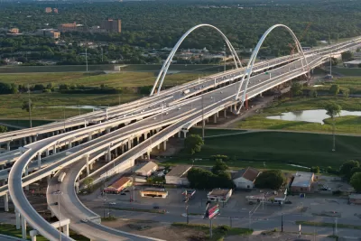
As noted by Harris, North Texas is quickly adding, over 100,000 new jobs between February 2018 and February 2019, and unemployment is below the national average. But with that growth comes challenges.
Land-use regulations in some established cities have pushed most of this growth out to the fringes of North Texas, in places like central and northern Collin and Denton counties, creating a serious transportation challenge. According to the consultancy INRIX, the average Dallas driver lost 76 hours every year to traffic congestion in 2018. And suburbs are developing in a way that leaves most people no choice but to drive everywhere — largely the result of regulations that require massive parking lots in every new development, making driving artificially cheap and walking unpleasant.
So travel times are increasing on average, even while travel distances are decreasing on average, and Harris sees reasons that congestion could slow economic mobility for the growing population. Harris's proposed solution: more zoning that allows for apartments in the region's suburbs, especially around DART stations. Still, according to Harris, all suburbs must have a role to overcome the challenges presented by its history of lad use regulations that only allow sprawling, single-family neighborhoods.
Housing prices will never moderate, though, unless suburban municipalities take a fresh look at their public policies. Zoning codes typically prohibit residential development in industrial and commercial zones, for example. Parking minimums, furthermore, require businesses to provide parking lots that can be several times larger than the stores they serve, as well as large amounts of parking — often two spaces per dwelling unit — in residential zones. The amount of land on which any residential development denser than single-family is prohibited, moreover, is almost certainly excessive.
FULL STORY: You can blame suburban zoning rules for your crushing commute


How Planning Fails to Solve Congestion
Solutions for congestion are never as simple and easy as armchair planners and engineers would like you to believe—especially those who suggest that congestion can be solved by forever building more roadway capacity.

Planning and the Complicated Causes and Effects of Congestion
What do planners know about congestion, and what can they do about it? Explanations and solutions are less obvious than they seem (part one of a three-part series).

Looking for a Starter Home in Dallas? Good Luck
According to a new study, fewer than 10 percent of homes in the Dallas-Fort Worth area are priced for first-time buyers.

Planetizen Federal Action Tracker
A weekly monitor of how Trump’s orders and actions are impacting planners and planning in America.

San Francisco's School District Spent $105M To Build Affordable Housing for Teachers — And That's Just the Beginning
SFUSD joins a growing list of school districts using their land holdings to address housing affordability challenges faced by their own employees.

The Tiny, Adorable $7,000 Car Turning Japan Onto EVs
The single seat Mibot charges from a regular plug as quickly as an iPad, and is about half the price of an average EV.

Seattle's Plan for Adopting Driverless Cars
Equity, safety, accessibility and affordability are front of mind as the city prepares for robotaxis and other autonomous vehicles.

As Trump Phases Out FEMA, Is It Time to Flee the Floodplains?
With less federal funding available for disaster relief efforts, the need to relocate at-risk communities is more urgent than ever.

With Protected Lanes, 460% More People Commute by Bike
For those needing more ammo, more data proving what we already knew is here.
Urban Design for Planners 1: Software Tools
This six-course series explores essential urban design concepts using open source software and equips planners with the tools they need to participate fully in the urban design process.
Planning for Universal Design
Learn the tools for implementing Universal Design in planning regulations.
Smith Gee Studio
City of Charlotte
City of Camden Redevelopment Agency
City of Astoria
Transportation Research & Education Center (TREC) at Portland State University
US High Speed Rail Association
City of Camden Redevelopment Agency
Municipality of Princeton (NJ)