


The New York City Department of City Planning has released a large set of recommendations for zoning changes designed to help the city's many coastal areas weather the inevitable extreme weather events of climate change and sea level rise.
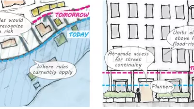
The New York City Department of City Planning (DCP) recently announced Zoning for Coastal Flood Resiliency, described in a press release as "a set of recommendations to help floodproof buildings in vulnerable neighborhoods against storms and incorporate sea level rise into their design as projected by the New York City Panel on Climate Change."
"Zoning for Coastal Flood Resiliency would expand the area where flood resilient zoning provisions apply, more than doubling the number of buildings that could utilize these provisions. It would accomplish this by allowing buildings in both the city’s 1% annual chance floodplain and 0.2% annual chance floodplain to fully meet or exceed flood-resistant construction standards, even when these standards are not required by FEMA and NYC’s Building Code," according to the press release.
The recommendations are a small step forward for the recommendations, following a public engagement process that briefed 2,500 stakeholders at 138 community events. "Environmental review and the formal public review process are anticipated to start before the end of the year," according to the press release.
The Zoning for Coastal Flood Resiliency recommendations are part of the Department of City Planning’s ongoing "climate resiliency initiatives." A lot more details about the recommendations are included in the press release and on a website set up to explain the recommendations.
FULL STORY: Department of City Planning Announces Zoning for Coastal Flood Resiliency

Proposed Citywide Rezoning Would Layer Resilience in New York City
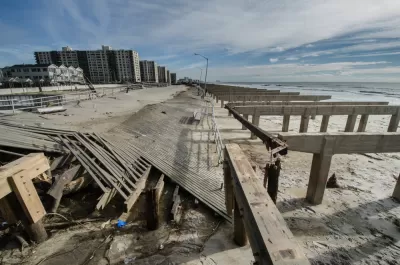
With 520 miles of coastline, New York City is ready to implement the lessons of Hurricane Sandy in the zoning code for the entire city.
'Zoning for Coastal Flood Resiliency' Wins Planning Commission Approval in NYC
Emergency responses to Hurricane Sandy have turned into long-term lessons in New York City, as the nation's largest city crafts a response to sea-level rise and extreme weather by making changes to the zoning code of coastal areas.

Lower Manhattan Climate Resilience Plan Released
The Financial District and Seaport Climate Resilience Master Plan will extend the shoreline in Lower Manhattan by up to 200 feet.

Maui's Vacation Rental Debate Turns Ugly
Verbal attacks, misinformation campaigns and fistfights plague a high-stakes debate to convert thousands of vacation rentals into long-term housing.

Planetizen Federal Action Tracker
A weekly monitor of how Trump’s orders and actions are impacting planners and planning in America.

San Francisco Suspends Traffic Calming Amidst Record Deaths
Citing “a challenging fiscal landscape,” the city will cease the program on the heels of 42 traffic deaths, including 24 pedestrians.

Adaptive Reuse Will Create Housing in a Suburban Texas Strip Mall
A developer is reimagining a strip mall property as a mixed-use complex with housing and retail.

Study: Anti-Homelessness Laws Don’t Work
Research shows that punitive measures that criminalized unhoused people don’t help reduce homelessness.

In U.S., Urban Gondolas Face Uphill Battle
Cities in Latin America and Europe have embraced aerial transitways — AKA gondolas — as sustainable, convenient urban transport, especially in tricky geographies. American cities have yet to catch up.
Urban Design for Planners 1: Software Tools
This six-course series explores essential urban design concepts using open source software and equips planners with the tools they need to participate fully in the urban design process.
Planning for Universal Design
Learn the tools for implementing Universal Design in planning regulations.
Heyer Gruel & Associates PA
JM Goldson LLC
Custer County Colorado
City of Camden Redevelopment Agency
City of Astoria
Transportation Research & Education Center (TREC) at Portland State University
Jefferson Parish Government
Camden Redevelopment Agency
City of Claremont