


Emergency responses to Hurricane Sandy have turned into long-term lessons in New York City, as the nation's largest city crafts a response to sea-level rise and extreme weather by making changes to the zoning code of coastal areas.
"The City Planning Commission (CPC) approved citywide zoning rules to protect coastal areas from flooding and sea level rise in a committee vote Wednesday," reports Chava Gourarie.
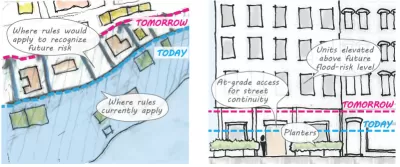
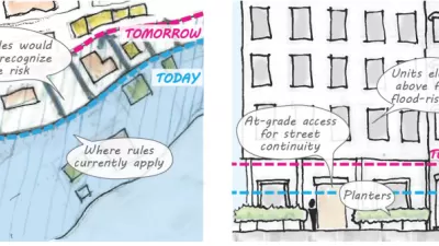
The new Zoning for Coastal Flood Resiliency (ZCFR) rules, detailed in an October 2020 Planetizen post, "would affect homes and buildings in areas designated as floodplains to ensure that they can withstand storms and other disasters, as well as recover from them quicker," explains Gourarie.
More specifically, according to Gourarie:
The proposed plan would allow existing homeowners and property owners to add resiliency measures, such as moving equipment to higher ground or elevating their structures. The new rules would allow more flexible zoning on new construction, introduce recovery measures that would be triggered by emergencies, expand the area eligible for the new zoning regulations, and restrict the number of new nursing homes built in flood zones.
If approved by the New York City Council, the zoning changes would permanently enshrine zoning changes implemented as an emergency measure after Hurricane Sandy.
More new coverage, by Mark Hallum, is available from AM New York. A press release from the New York City Department of City Planning includes soundbites on the approval from New York City Planning Commission Chair Marissa Lago.
FULL STORY: City Planning Commission Approves Citywide Coastal Zoning Rules

Proposed Citywide Rezoning Would Layer Resilience in New York City
With 520 miles of coastline, New York City is ready to implement the lessons of Hurricane Sandy in the zoning code for the entire city.

In Battery Park City, Public Infrastructure Meets Climate Resilience
A massive project underway in Lower Manhattan seeks to protect the shoreline from future flooding and mitigate the effects of climate change and rising sea levels.

Net Zero Development Coming to New York City
The project, which relies largely on geothermal energy to minimize its carbon footprint, will bring affordable housing and boost storm resilience to an area devastated by Hurricane Sandy.

Maui's Vacation Rental Debate Turns Ugly
Verbal attacks, misinformation campaigns and fistfights plague a high-stakes debate to convert thousands of vacation rentals into long-term housing.

Planetizen Federal Action Tracker
A weekly monitor of how Trump’s orders and actions are impacting planners and planning in America.

In Urban Planning, AI Prompting Could be the New Design Thinking
Creativity has long been key to great urban design. What if we see AI as our new creative partner?

King County Supportive Housing Program Offers Hope for Unhoused Residents
The county is taking a ‘Housing First’ approach that prioritizes getting people into housing, then offering wraparound supportive services.

Researchers Use AI to Get Clearer Picture of US Housing
Analysts are using artificial intelligence to supercharge their research by allowing them to comb through data faster. Though these AI tools can be error prone, they save time and housing researchers are optimistic about the future.

Making Shared Micromobility More Inclusive
Cities and shared mobility system operators can do more to include people with disabilities in planning and operations, per a new report.
Urban Design for Planners 1: Software Tools
This six-course series explores essential urban design concepts using open source software and equips planners with the tools they need to participate fully in the urban design process.
Planning for Universal Design
Learn the tools for implementing Universal Design in planning regulations.
planning NEXT
Appalachian Highlands Housing Partners
Mpact (founded as Rail~Volution)
City of Camden Redevelopment Agency
City of Astoria
City of Portland
City of Laramie