


The design of intersections between major roadways and bike and pedestrian paths can have fatal consequences.
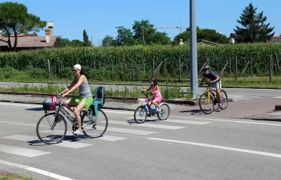
Using an example from a New Jersey segment of the East Coast Greenway, the nation’s longest biking and walking route, Asia Mieleszko highlights the danger raised by the intersection of greenways with highways and major arterial roads.
“While its most beloved segments are secluded and separated from motorized traffic, as much as 65% of the ECG involves interacting with cars and trucks that are moving at high speeds.” This puts the people biking and walking on the trail at risk, and has in some cases resulted in fatal crashes. In many places, the crossings are denoted only by a painted crosswalk, and drivers routinely ignore speed limits.
One problem, Mieleszko points out, is that the standards that county roads are held to often don’t match up with local realities. “ Often, they’re thought of as connectors between distant places, a means of getting from one side of town to the other, from one city to another dozens of miles away. As such, they prioritize the speed and throughput of vehicles in order to make that ride from A to B as efficient and seamless as possible.”
In practice, many of the country’s most dangerous, fast-moving roads intersect with pathways for people walking and biking. It takes consistent effort from local advocates to get state and county agencies to make changes that could, in theory, contradict their mandate to maintain fast traffic throughput.
FULL STORY: A Disaster Waiting to Happen: Where Our Greenways Meet Our Highways

Has Progress on Travel Safety Run Off the Road?
Changing technology and rebuilding infrastructure to improve road safety are long-term strategies. How can enforcement and interventions that influence driver behavior make a difference in reducing traffic deaths sooner?
NACTO Releases Updated Urban Bikeway Guide
The third edition of the nationally recognized road design guide includes detailed design advice for roads that prioritize safety and accessibility for all users.
Fixing the ‘Legacy’ Highways That Don’t Work for Anyone
A classic example of the notorious ‘stroad,’ aging state roads that aim to serve all users with piecemeal infrastructure solutions fail to facilitate safe, efficient transportation.

Maui's Vacation Rental Debate Turns Ugly
Verbal attacks, misinformation campaigns and fistfights plague a high-stakes debate to convert thousands of vacation rentals into long-term housing.

Planetizen Federal Action Tracker
A weekly monitor of how Trump’s orders and actions are impacting planners and planning in America.

San Francisco Suspends Traffic Calming Amidst Record Deaths
Citing “a challenging fiscal landscape,” the city will cease the program on the heels of 42 traffic deaths, including 24 pedestrians.

Adaptive Reuse Will Create Housing in a Suburban Texas Strip Mall
A developer is reimagining a strip mall property as a mixed-use complex with housing and retail.

Study: Anti-Homelessness Laws Don’t Work
Research shows that punitive measures that criminalized unhoused people don’t help reduce homelessness.

In U.S., Urban Gondolas Face Uphill Battle
Cities in Latin America and Europe have embraced aerial transitways — AKA gondolas — as sustainable, convenient urban transport, especially in tricky geographies. American cities have yet to catch up.
Urban Design for Planners 1: Software Tools
This six-course series explores essential urban design concepts using open source software and equips planners with the tools they need to participate fully in the urban design process.
Planning for Universal Design
Learn the tools for implementing Universal Design in planning regulations.
Heyer Gruel & Associates PA
JM Goldson LLC
Custer County Colorado
City of Camden Redevelopment Agency
City of Astoria
Transportation Research & Education Center (TREC) at Portland State University
Jefferson Parish Government
Camden Redevelopment Agency
City of Claremont