


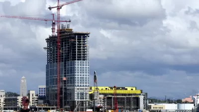
A recent package of code changes by the city of San Diego will make it possible to build high-rise residential buildings and accessory dwelling units in larger areas around public transit.

The city of San Diego recently approved an ordinance that will allow high-rise apartment buildings and accessory dwelling units in a larger portion of the city by expanding the boundaries of zoning for transit oriented development from a half-mile to a mile radius around transit stations. Specifically, the expanded zoning districts will allow high-rise apartment buildings and accessory dwelling units on more parcels in the city.
David Garrick last week broke the news of the ordinance’s approval for the San Diego Union-Tribune and Globe St. also picked up the news this week. Planetizen shared news of the ordinance in January, before it went up for approval by the San Diego City Council.
Garrick’s article provides more insight into the debate that preceded the 5-4 vote that approved the ordinance. Opponents on the City Council argued that one-mile is too far to walk, and the ordinance would create congestion due to the additional car trips created by new residential density. Proponents argues that the zoning change would create opportunities for more housing affordable at low- and middle-incomes.
As noted by Garrick, the zoning changes discussed here were included in a package of 84 total municipal code changes. “The other changes include outlawing storage facilities in prime industrial areas, expanding where tasting rooms are allowed and making downtown more family-friendly with new incentives for three-bedroom apartments and child care businesses,” and “Additional changes approved Tuesday as part of the annual code update include tougher rules for new projects vulnerable to sea-level rise and stronger wildfire prevention rules for climate-friendly energy storage facilities.”
Garrick’s article, linked below, suggests that the zoning change came about as a response to pressure from state housing regulators during the Regional Housing Needs Assessment process, which has been upending planning the state of California for the past year, and will continue to do so for the foreseeable future.
FULL STORY: Badly needed homes, or ‘infill sprawl?’ City approves controversial plan for high-rises farther from transit

Zoning Change for Mixed-Use Developments, Density Near Transit Moves Forward
Until now, mixed-use projects have required a lengthy discretionary approval process in San Diego. That could change with a zoning change given preliminary approval by the City Council this week.
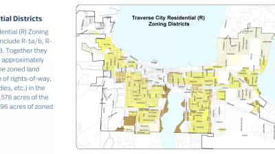
ADUs, Minimum Lot Sizes, and Quadplexes Under Discussion in Traverse City
Zoning changes for everything from housing density to minimum lot sizes are under consideration for a city on the shores of Lake Michigan.

San Diego Planning Commission Rejects Voluntary State Density Law
The density-enabling mechanisms of the California law Senate Bill 10 are too much for San Diego’s citizen planners.

Planetizen Federal Action Tracker
A weekly monitor of how Trump’s orders and actions are impacting planners and planning in America.

Map: Where Senate Republicans Want to Sell Your Public Lands
For public land advocates, the Senate Republicans’ proposal to sell millions of acres of public land in the West is “the biggest fight of their careers.”

Restaurant Patios Were a Pandemic Win — Why Were They so Hard to Keep?
Social distancing requirements and changes in travel patterns prompted cities to pilot new uses for street and sidewalk space. Then it got complicated.

Platform Pilsner: Vancouver Transit Agency Releases... a Beer?
TransLink will receive a portion of every sale of the four-pack.

Toronto Weighs Cheaper Transit, Parking Hikes for Major Events
Special event rates would take effect during large festivals, sports games and concerts to ‘discourage driving, manage congestion and free up space for transit.”

Berlin to Consider Car-Free Zone Larger Than Manhattan
The area bound by the 22-mile Ringbahn would still allow 12 uses of a private automobile per year per person, and several other exemptions.
Urban Design for Planners 1: Software Tools
This six-course series explores essential urban design concepts using open source software and equips planners with the tools they need to participate fully in the urban design process.
Planning for Universal Design
Learn the tools for implementing Universal Design in planning regulations.
Heyer Gruel & Associates PA
JM Goldson LLC
Custer County Colorado
City of Camden Redevelopment Agency
City of Astoria
Transportation Research & Education Center (TREC) at Portland State University
Camden Redevelopment Agency
City of Claremont
Municipality of Princeton (NJ)