


Increasing density in the neighborhoods surrounding the new subway stops would bring more affordable, transit-adjacent housing to East Harlem and boost ridership.
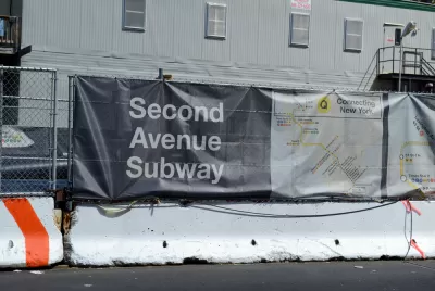
Nicholas D. Bloom describes the changes he deems necessary for New York's Second Avenue Subway to have the most positive impact on the surrounding community. "The Second Avenue Subway three-stop extension will likely become the nation’s most expensive urban mass transit project. Still, it will fail to benefit many city residents unless significant zoning changes are made to the neighborhood," writes Bloom.
"High-quality planning and significant upzoning could boost ridership on the new line and remake East Harlem into a place that more comfortably accommodates current and future residents–of all income levels." Bloom points to the first phase of the Second Avenue line, which serves the affluent East Side, a neighborhood "characterized by large apartment buildings permitted primarily by R8 and R10 zoning." Thanks to this high density, the line attracted 200,000 subway riders per day upon its opening.
However, "Extending the subway line in East Harlem along Second Avenue between 96th Street and 125th Streets is a different story. The neighborhood's threadbare low-rise tenements remain a dominant feature." Upzoning these neighborhoods, Bloom argues, would bring more housing near transit and boost ridership. "The rezoning should be at levels similar to the dense neighborhoods (R8-R10) below 96th Street on the Second Avenue Subway corridor. Only much greater residential zoning in East Harlem can attract developers and drive the creation of sufficient market housing to cross-subsidize thousands of additional low-cost units in East Harlem."
Bloom writes, "Leaving current zoning/density in advance of the subway extension is a vote for market-driven gentrification. Big money will inevitably follow the subway lines into East Harlem. Left to their own devices, developers will add few affordable units in new buildings permitted under current zoning."
FULL STORY: How the Next Phase of the Second Avenue Subway Can Build a Better East Harlem


NYC Council Approves Brooklyn Rezoning Plan
The Atlantic Avenue Mixed Use Plan includes infrastructure investments and could bring 4,600 new housing units to parts of Brooklyn.

Lawsuit Aims to Stop NYC’s ‘City of Yes’ Zoning Reforms
A lawsuit brought by local lawmakers and community groups claims the plan failed to conduct a comprehensive environmental review.
NYC Zoning Reform: Where Will It Have an Impact?
The zoning reform package dubbed ‘City of Yes’ will likely yield uneven results, with many of the lowest-density neighborhoods exempted from new regulations.

Maui's Vacation Rental Debate Turns Ugly
Verbal attacks, misinformation campaigns and fistfights plague a high-stakes debate to convert thousands of vacation rentals into long-term housing.

Planetizen Federal Action Tracker
A weekly monitor of how Trump’s orders and actions are impacting planners and planning in America.

San Francisco Suspends Traffic Calming Amidst Record Deaths
Citing “a challenging fiscal landscape,” the city will cease the program on the heels of 42 traffic deaths, including 24 pedestrians.

Defunct Pittsburgh Power Plant to Become Residential Tower
A decommissioned steam heat plant will be redeveloped into almost 100 affordable housing units.

Trump Prompts Restructuring of Transportation Research Board in “Unprecedented Overreach”
The TRB has eliminated more than half of its committees including those focused on climate, equity, and cities.

Amtrak Rolls Out New Orleans to Alabama “Mardi Gras” Train
The new service will operate morning and evening departures between Mobile and New Orleans.
Urban Design for Planners 1: Software Tools
This six-course series explores essential urban design concepts using open source software and equips planners with the tools they need to participate fully in the urban design process.
Planning for Universal Design
Learn the tools for implementing Universal Design in planning regulations.
Heyer Gruel & Associates PA
JM Goldson LLC
Custer County Colorado
City of Camden Redevelopment Agency
City of Astoria
Transportation Research & Education Center (TREC) at Portland State University
Jefferson Parish Government
Camden Redevelopment Agency
City of Claremont