


How did ZIP codes become such powerful determinants of public health? New new evidence of the disparate air pollution of redlined neighborhoods partly answers that question.
A study published today by the Environmental Science and Technology Letters connects the racial disparities of air pollution of contemporary U.S. cities to the redlining practices originating in the New Deal of the 1930s. The new research adds to a body of work revealing the environmental justice legacy of redlining—previous studies documented the persistence of urban heat islands, lack of tree canopy, and lack of green space in formerly redlined neighborhoods.
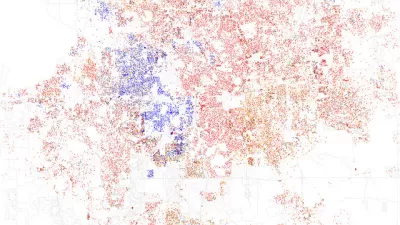
The study, written by researchers at the University of California, Berkeley and the University of Washington, studied intraurban air pollution disparities in 202 U.S. cities, comparing Home Owners’ Loan Corporation (HOLC) maps of investment risk grades (i.e., redlining maps) to 2010 estimates of NO2 and PM2.5 air pollution levels, and demographic information from the 2010 U.S. census. The researchers find clear evidence that the legacy of redlining is written on the lungs of the communities of color still living in formerly redlined neighborhoods. Moreover, while communities of color are subject to higher levels of pollution at every income level, intraurban disparities for NO2 and PM2.5 are substantially larger by historical HOLC grade than they are by race and ethnicity, according to the study.
The study attracted attention from two of the nation's largest daily newspapers—the New York Times and the Washington Post—both of which published articles about the study at exactly 8 am ET this morning.
Writing for the Washington Post, Darryl Fears begins by adding depressed home values, lower economic mobility, and high levels of poverty to the list of contemporary consequences of redlining, in addition to the air pollution, excessive heat, and lack of tree canopy and park space mentioned above.
"The practice known as redlining was outlawed more than a half-century ago, but it continues to impact people who live in neighborhoods that government mortgage officers shunned for 30 years because people of color and immigrants lived in them," writes Fears to introduce the concept of redlining to the uninitiated.
The analysis, published in the journal Environmental Science and Technology Letters, found that, compared with White people, Black and Latino Americans live with more smog and fine particulate matter from cars, trucks, buses, coal plants and other nearby industrial sources in areas that were redlined. Those pollutants inflame human airways, reduce lung function, trigger asthma attacks and can damage the heart and cause strokes.
The coverage from the Washington Post includes useful infographics.
Writing for the New York Times, Raymond Zhong and Nadja Popovich helpfully document the demographic legacy of redlining underlying the news about air pollution disparities: "To this day, historically redlined neighborhoods are more likely to have high populations of Black, Latino and Asian residents than areas that were favorably assessed at the time."
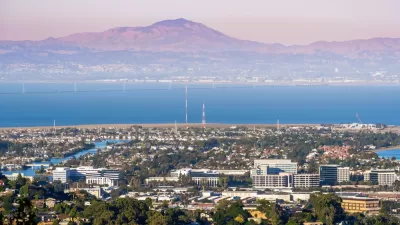
Maps included in the New York Times article feature the East San Francisco Bay Area as a clear example of the study's findings.
"The neighborhoods within Berkeley and Oakland that were redlined sit on lower-lying land, closer to industry and bisected by major highways. People in those areas experience levels of nitrogen dioxide that are twice as high as in the areas that federal surveyors in the 1930s designated as 'best,' or most favored for investment, according to the new pollution study," write Zhong and Popovich.
FULL STORY: Historical Redlining Is Associated with Present-Day Air Pollution Disparities in U.S. Cities

Pollution Does Discriminate in Orlando’s Parramore Neighborhood
Poor air quality has decimated the health of residents in this predominantly black community ringed by highways.
Court Complaint Accuses Redfin's 'Minimum Price Policy' of Redlining Minority Neighborhoods
A bombshell investigation accuses an online real estate company of a contemporary form of redlining.
Racial Disparity in Home Lending Is Today's Redlining
According to a new report detailing discriminatory lending in Chicago, people in majority-white neighborhoods continue to receive more loans, and in greater amounts, than people in majority-Black and majority-Latino areas.

Maui's Vacation Rental Debate Turns Ugly
Verbal attacks, misinformation campaigns and fistfights plague a high-stakes debate to convert thousands of vacation rentals into long-term housing.

Planetizen Federal Action Tracker
A weekly monitor of how Trump’s orders and actions are impacting planners and planning in America.

In Urban Planning, AI Prompting Could be the New Design Thinking
Creativity has long been key to great urban design. What if we see AI as our new creative partner?

Chicago’s Ghost Rails
Just beneath the surface of the modern city lie the remnants of its expansive early 20th-century streetcar system.

Baker Creek Pavilion: Blending Nature and Architecture in Knoxville
Knoxville’s urban wilderness planning initiative unveils the "Baker Creek Pavilion" to increase the city's access to green spaces.

Pedestrian Deaths Drop, Remain Twice as High as in 2009
Fatalities declined by 4 percent in 2024, but the U.S. is still nowhere close to ‘Vision Zero.’
Urban Design for Planners 1: Software Tools
This six-course series explores essential urban design concepts using open source software and equips planners with the tools they need to participate fully in the urban design process.
Planning for Universal Design
Learn the tools for implementing Universal Design in planning regulations.
planning NEXT
Appalachian Highlands Housing Partners
Mpact (founded as Rail~Volution)
City of Camden Redevelopment Agency
City of Astoria
City of Portland
City of Laramie