


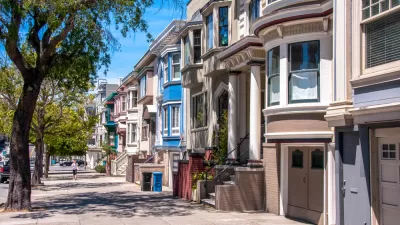
When writing city plans, past planners in San Francisco got some things just right—and some very wrong.

Our readers don't need to be told that city planning is a complicated endeavor. As John King writes, the history of San Francisco's urban plans provides an illuminating example of how assumptions about urban growth can be short-sighted or naive.
King gives five examples of policies that have not panned out in the way the city expected. For example, the elevated pedestrian walkways designed in the 1960s to help pedestrians cross streets more safely have proven to deaden street life, falling out of favor with contemporary planners. Meanwhile, a law that restricted building heights near freeways in order to preserve "views" for drivers has become obsolete as planners now view high-rise towers as an appropriate way to increase density and put more housing near economic centers and transit.
As King notes, the city's 1985 Downtown Plan called for buildings that maintained the "complex architectural qualities of older San Francisco buildings," but today's planners see modern design as a potential boon to historic neighborhoods.
San Francisco plans in the 1990s also emphasized the importance of the ground floor, mandating first-floor residential units and retail. While ground-floor retail remains an important cornerstone of walkable urbanism, competition from big-box stores, high rents, and hostility from landlords mean that many of these spaces remain vacant, failing to bring the "eyes on the street" that planners desire.
Ultimately, King's observations show that urban design and planning are living, evolving fields, and planning documents should reflect a consistent reevaluation of interventions and their real-world results.
FULL STORY: You think planning a city like S.F. is easy? Here are five things that planners got wrong

Whose History Is Being Preserved, Exactly?
As the housing crisis continues, advocates are increasingly wary of historic preservation efforts that serve to perpetuate historic inequities and keep housing costs high.
San Francisco Fourplex Proposal Could Skirt State Law
A proposal before the Board of Supervisors could undermine the state's density law by upzoning the city to allow duplexes, a step housing advocates call a disingenuous effort to prevent higher density.
San Francisco's 1971 Urban Design Plan Echoes Today's Concerns
A 1971 effort to quantify the city's values and design goals reflects many of the same priorities that planners and residents face today.

Planetizen Federal Action Tracker
A weekly monitor of how Trump’s orders and actions are impacting planners and planning in America.

Map: Where Senate Republicans Want to Sell Your Public Lands
For public land advocates, the Senate Republicans’ proposal to sell millions of acres of public land in the West is “the biggest fight of their careers.”

Restaurant Patios Were a Pandemic Win — Why Were They so Hard to Keep?
Social distancing requirements and changes in travel patterns prompted cities to pilot new uses for street and sidewalk space. Then it got complicated.

Platform Pilsner: Vancouver Transit Agency Releases... a Beer?
TransLink will receive a portion of every sale of the four-pack.

Toronto Weighs Cheaper Transit, Parking Hikes for Major Events
Special event rates would take effect during large festivals, sports games and concerts to ‘discourage driving, manage congestion and free up space for transit.”

Berlin to Consider Car-Free Zone Larger Than Manhattan
The area bound by the 22-mile Ringbahn would still allow 12 uses of a private automobile per year per person, and several other exemptions.
Urban Design for Planners 1: Software Tools
This six-course series explores essential urban design concepts using open source software and equips planners with the tools they need to participate fully in the urban design process.
Planning for Universal Design
Learn the tools for implementing Universal Design in planning regulations.
Heyer Gruel & Associates PA
JM Goldson LLC
Custer County Colorado
City of Camden Redevelopment Agency
City of Astoria
Transportation Research & Education Center (TREC) at Portland State University
Camden Redevelopment Agency
City of Claremont
Municipality of Princeton (NJ)