


A 1971 effort to quantify the city's values and design goals reflects many of the same priorities that planners and residents face today.
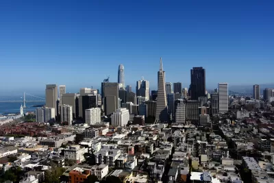
In 1971, San Francisco published its Urban Design Plan, a blueprint for preserving the character of the city and addressing growing concerns about building height and density. John King describes the plan, which warned against "unstructured and unabated growth" and the "jarring disharmony" caused by 'unusual' buildings like the Transamerica Pyramid, approved for construction in 1969.
The plan also acknowledged the role of high-rises in the growing city, "a necessary and expressive form for much of the city’s office, apartment, hotel and institutional development," and encourages 'respectful' new development that fits into the city's unique environment.
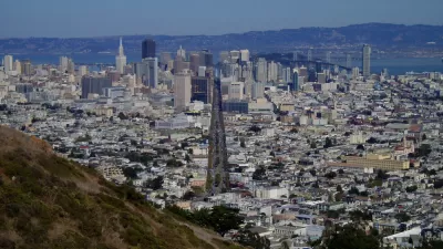
The plan includes a wealth of photos, sketches, and maps that illustrate the planners' ideas about creating a pleasant urban environment and their design best-practices.
Notably, the plan calls for reducing traffic in residential areas through what we now call traffic calming measures such as narrowed streets, landscaping, and traffic diversion. Planners in 1971 also suggested "close by and visible" parks, pointing to the city's waterfront as an underused recreational space. As King notes, "This was written 20 years before the Embarcadero Freeway was torn down, and 30 years before Crissy Field opened in the Presidio."
The conclusion we can draw from the plan more broadly, writes King, is the idea that the city's fractious population can come to some agreement on what they value in their built environment—and that San Franciscans love their city enough to fight for it.
FULL STORY: Planners tried to define what makes San Francisco special — in 1971. Here’s how their designs fared

San Francisco Could Strike Deal on New Tower
The city is leveraging height increases and density bonuses to acquire more properties for affordable housing.
How the Built Environment Impacts Public Health
New research sheds light on how the brain responds to urban environments and architecture.

Is it Time to Revive the Pattern Language?
Software and other fields have made brilliant progress with the pattern language methodology, while built environment fields lag badly, mired in parochial debates over the massive book that invented the methodology.

Maui's Vacation Rental Debate Turns Ugly
Verbal attacks, misinformation campaigns and fistfights plague a high-stakes debate to convert thousands of vacation rentals into long-term housing.

Planetizen Federal Action Tracker
A weekly monitor of how Trump’s orders and actions are impacting planners and planning in America.

San Francisco Suspends Traffic Calming Amidst Record Deaths
Citing “a challenging fiscal landscape,” the city will cease the program on the heels of 42 traffic deaths, including 24 pedestrians.

Defunct Pittsburgh Power Plant to Become Residential Tower
A decommissioned steam heat plant will be redeveloped into almost 100 affordable housing units.

Trump Prompts Restructuring of Transportation Research Board in “Unprecedented Overreach”
The TRB has eliminated more than half of its committees including those focused on climate, equity, and cities.

Amtrak Rolls Out New Orleans to Alabama “Mardi Gras” Train
The new service will operate morning and evening departures between Mobile and New Orleans.
Urban Design for Planners 1: Software Tools
This six-course series explores essential urban design concepts using open source software and equips planners with the tools they need to participate fully in the urban design process.
Planning for Universal Design
Learn the tools for implementing Universal Design in planning regulations.
Heyer Gruel & Associates PA
JM Goldson LLC
Custer County Colorado
City of Camden Redevelopment Agency
City of Astoria
Transportation Research & Education Center (TREC) at Portland State University
Jefferson Parish Government
Camden Redevelopment Agency
City of Claremont