


A closely watched rezoning effort in New York City cleared a key City Council committee last week, while making some concessions from the original vision to get across the finish line.
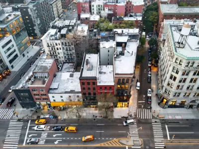
Kathryn Brenzel reports for TheRealDeal that the New York City Council has reached a compromise to get Envision SoHo/NoHo one critical step closer to full approval, dialing back some of the density in the vision for this relatively wealthy corner of Manhattan.
The version of the plan approved by the City Council's Committee on Land Use last week "reduces the commercial floor-area ratio in most of the rezoning area to 5 from the original proposal, in which FAR was 10 in three areas," reports Brenzel. "In the Bowery corridor in Noho, the commercial FAR is 7 and the residential FAR is 12, as recommended by City Planning."
"Despite the last-minute changes, the plan as a whole will dramatically increase the amount of development allowed in the high-income, relatively low-scale neighborhoods. It is a victory for the administration and advocates for affordable housing, not to mention the real estate industry," writes Brenzel.
Planners in New York City began working on the controversial rezoning plan in 2018, and the narrative about the rezoning process quickly turned to relative wealth of the neighborhoods included in the plan compared to other parts of the city rezoned during the de Blasio administration (advocates are pushing the city to for rezone for more residential density in other affluent parts of the city in the wake of Envision SoHo/NoHo).
More details on the final plan are available in the source article linked below. An earlier article by Brenzel, published two days earlier, detailed the political maneuvers that preceded to the compromise.
FULL STORY: City Council tweaks Soho rezoning, assuring its passage

Too Much Commercial Zoning for Affordable Housing in SoHo's Controversial Rezoning Plan?
Mayor Bill de Blasio is crossing the finish line of his time in office at the same time as one of the most controversial rezoning processes of his administration.

New Supertall Planned for Grand Central Station-Adjacent Property
A new supertall skyscraper will rise at 175 Park Avenue, rising next to famous neighbors on a prime block in Manhattan.
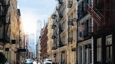
Five More Affluent NYC Neighborhoods to Upzone
In keeping with the goals of the Regional Plan Association's Fourth Regional Plan, New York City must continue its nascent trend of rezoning for more building capacity in affluent neighborhoods.

Planetizen Federal Action Tracker
A weekly monitor of how Trump’s orders and actions are impacting planners and planning in America.

Map: Where Senate Republicans Want to Sell Your Public Lands
For public land advocates, the Senate Republicans’ proposal to sell millions of acres of public land in the West is “the biggest fight of their careers.”

Restaurant Patios Were a Pandemic Win — Why Were They so Hard to Keep?
Social distancing requirements and changes in travel patterns prompted cities to pilot new uses for street and sidewalk space. Then it got complicated.

Platform Pilsner: Vancouver Transit Agency Releases... a Beer?
TransLink will receive a portion of every sale of the four-pack.

Toronto Weighs Cheaper Transit, Parking Hikes for Major Events
Special event rates would take effect during large festivals, sports games and concerts to ‘discourage driving, manage congestion and free up space for transit.”

Berlin to Consider Car-Free Zone Larger Than Manhattan
The area bound by the 22-mile Ringbahn would still allow 12 uses of a private automobile per year per person, and several other exemptions.
Urban Design for Planners 1: Software Tools
This six-course series explores essential urban design concepts using open source software and equips planners with the tools they need to participate fully in the urban design process.
Planning for Universal Design
Learn the tools for implementing Universal Design in planning regulations.
Heyer Gruel & Associates PA
JM Goldson LLC
Custer County Colorado
City of Camden Redevelopment Agency
City of Astoria
Transportation Research & Education Center (TREC) at Portland State University
Camden Redevelopment Agency
City of Claremont
Municipality of Princeton (NJ)