


The new formulas for calculating the length of walk signals are designed to give people more time to safely cross the street.
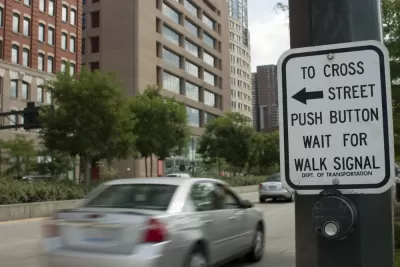
"Determining how much time a pedestrian needs to safely cross the road at a crosswalk is surprisingly complicated," writes Michelle Baruchman in the Seattle Times. City engineers employ "a set of formulas that consider the width of the street, an average walking pace and intersection design, among other things" to calculate the amount of time needed for each intersection. Until recently, the Seattle Department of Transportation (SDOT) used an average walking speed of 3.5 feet per second. "Now, through conversations with a pedestrian-focused advisory group, SDOT has updated its guidelines to give people a little more time to cross — a move celebrated by advocates for seniors and people with disabilities."
Pedestrian advocates applaud the move as one of many possible "seemingly small tweaks" that "can make a big difference in street safety, without requiring major construction or costs." Akira Ohiso, a social worker with Sound Generations, an organization that provides activities for seniors, cited prior conditions as unsafe, saying that "crosswalks in busy urban streets do not allow enough time for older adults to cross safely, especially four-lane streets." The new guidelines call for recalculating the timing "when existing intersections are modified, when community members request a change and when new signals are installed." For drivers, the changes will "mostly balance out," according to SDOT spokesperson Ethan Bergerson, as "slightly longer red lights usually also lead to longer green lights."
The change comes as part of a broader move to improve pedestrian safety in the city that includes curb bulbs, leading pedestrian intervals, and guidance on whether intersections require push-to-walk buttons or automatic signals.
FULL STORY: Why the ‘walk’ signals at some Seattle crosswalks seem a little longer now

Austin Adds Pedestrian Improvements at Hundreds of Intersections
The city added leading pedestrian interval technology to over 600 intersections, giving pedestrians time to cross before vehicles.

Without Sidewalks, Making Seattle Streets More Pedestrian Friendly
Over a quarter of city blocks lack sidewalk infrastructure. An advocacy project to reduce traffic speeds and increase pedestrian safety on these streets has evolved into a city-funded program.

Chicago Judge Orders Thousands of Accessible Ped Signals
Only 3% of the city's crossing signals are currently accessible to blind pedestrians.

Planetizen Federal Action Tracker
A weekly monitor of how Trump’s orders and actions are impacting planners and planning in America.

Maui's Vacation Rental Debate Turns Ugly
Verbal attacks, misinformation campaigns and fistfights plague a high-stakes debate to convert thousands of vacation rentals into long-term housing.

Restaurant Patios Were a Pandemic Win — Why Were They so Hard to Keep?
Social distancing requirements and changes in travel patterns prompted cities to pilot new uses for street and sidewalk space. Then it got complicated.

In California Battle of Housing vs. Environment, Housing Just Won
A new state law significantly limits the power of CEQA, an environmental review law that served as a powerful tool for blocking new development.

Boulder Eliminates Parking Minimums Citywide
Officials estimate the cost of building a single underground parking space at up to $100,000.

Orange County, Florida Adopts Largest US “Sprawl Repair” Code
The ‘Orange Code’ seeks to rectify decades of sprawl-inducing, car-oriented development.
Urban Design for Planners 1: Software Tools
This six-course series explores essential urban design concepts using open source software and equips planners with the tools they need to participate fully in the urban design process.
Planning for Universal Design
Learn the tools for implementing Universal Design in planning regulations.
Heyer Gruel & Associates PA
JM Goldson LLC
Custer County Colorado
City of Camden Redevelopment Agency
City of Astoria
Transportation Research & Education Center (TREC) at Portland State University
Jefferson Parish Government
Camden Redevelopment Agency
City of Claremont